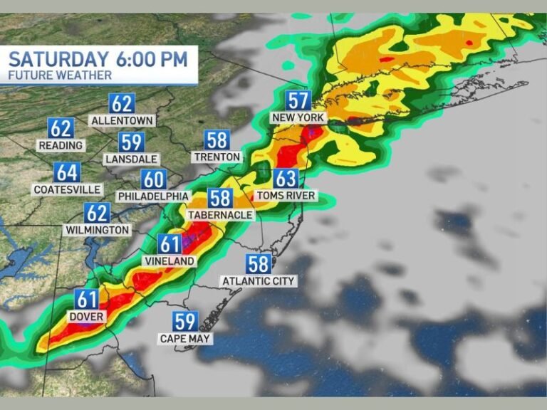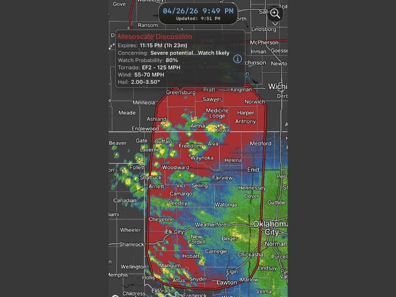
Severe Mesoscale Discussion Issued Across Western Oklahoma and Southwestern Kansas With Baseball Sized Hail and Strong Tornado Threat Overnight
WOODWARD, OK — A Mesoscale Discussion was issued across Western Oklahoma and Southwestern Kansas as a rapidly intensifying severe weather threat raised alarm across a wide swath of the region, with an 80 percent probability of a tornado watch being issued for the overnight hours. The discussion, expiring at 11:15 PM, flagged a dangerous combination of threats including EF2-level tornado potential with winds up to 125 miles per hour, straight-line winds of 55 to 70 miles per hour, and hail ranging from 2.00 to 3.50 inches in diameter.
A New Wave of Energy Ignites the Threat
The primary driver behind the escalating severe weather setup was a main wave of energy pushing out of New Mexico, moving into already volatile atmospheric conditions across the region. Meteorological conditions were primed for rapid storm development as this energy collided with existing instability across Western Oklahoma and Southwestern Kansas.
The new round of storms carried the potential to produce all hazard types simultaneously, making the overnight period particularly dangerous for communities spread across a large geographic area on both sides of the Kansas-Oklahoma border.
Communities Across Two States at Risk
The Mesoscale Discussion area encompassed a broad and heavily populated region. Communities including Woodward, Enid, Alva, Elk City, Medicine Lodge, Pratt, Kingman, and Greensburg all fell within the outlined threat zone.
Further south, major population centers including Oklahoma City, Guthrie, Norman, Chickasha, and Weatherford were also captured within the warning boundary, reflecting the extraordinary geographic scale of the developing severe weather system.
Hail and Tornado Threats Demand Immediate Attention
Baseball-sized hail measuring between 2.00 and 3.50 inches represented one of the most physically destructive elements of the forecast. Hail of this size causes severe damage to rooftops, vehicles, and any exposed property, posing a direct life-threatening risk to individuals caught outdoors.
Alongside the hail threat, strong tornado development remained a primary concern through the overnight hours, with EF2-level potential signaling winds capable of destroying manufactured homes, snapping large trees, and causing significant structural damage to well-built residences.
Overnight Timing Adds to the Danger
The overnight nature of the threat significantly compounded the danger for residents across the region. Nighttime tornado events are historically more deadly due to reduced visibility and the inability of residents to visually identify approaching storms.
With a tornado watch carrying an 80 percent probability of issuance, residents across the entire warned region were urged to remain alert, keep weather radios active, and have a clear shelter plan ready through the overnight hours. For continuing coverage of severe weather events and critical storm analysis across the United States, visit SaludaStandard-Sentinel.com.