Dangerous Situation Tornado Warning Confirmed Near Columbus Threatens Southwestern Missouri and Eastern Kansas With Significant Damage Expected
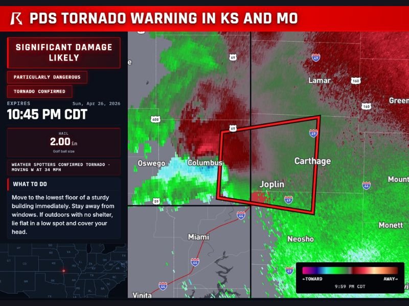
COLUMBUS, MO — A Particularly Dangerous Situation tornado warning was issued across Southwestern Missouri and Eastern Kansas on the evening of April 26, 2026, as weather spotters confirmed a large and extremely dangerous tornado on the ground near Columbus.
The warning, set to expire at 10:45 PM CDT, covered a broad stretch of communities including Columbus, Carthage, Joplin, Oswego, Neosho, and Lamar, placing thousands of residents in the direct path of a confirmed, violently rotating storm system.
What Makes This a Particularly Dangerous Situation
A Particularly Dangerous Situation, commonly referred to as a PDS designation, is one of the most severe classifications the National Weather Service can attach to a tornado warning. It signals that atmospheric conditions are highly favorable for a long-track, violent tornado capable of producing catastrophic and widespread destruction across significant distances.
The PDS classification applied to this event reflected the confirmed and ongoing nature of the tornado, with weather spotters on the ground verifying the tornado’s presence near Columbus before the warning was widely disseminated to the public.
Tornado Confirmed Moving West Toward Dense Communities
Weather spotters confirmed the tornado was actively on the ground and moving westward at 34 miles per hour. The storm’s trajectory placed Carthage and Joplin directly in its path — both communities representing significant population centers within the affected region of Southwestern Missouri.
Radar imagery captured through weatherwise.app showed intense rotational velocity signatures consistent with a large and well-organized supercell thunderstorm. The warning polygon, outlined in red across radar displays, encompassed a wide geographic area running through the heart of the Kansas-Missouri border region.
Hail and Compounding Hazards Reported
In addition to the confirmed tornado, the warning highlighted a significant hail threat accompanying the storm system. Hail of up to 2.00 inches in diameter, equivalent to golf ball size, was reported with the supercell. Hail of this magnitude poses serious risks to property, vehicles, and individuals caught outdoors without adequate shelter.
The combination of a confirmed tornado, golf ball-sized hail, and a PDS classification made this one of the most dangerous storm events to impact Southwestern Missouri and Eastern Kansas in recent memory.
Life-Threatening Conditions and Immediate Safety Guidance
Residents across the warned area were urged to take immediate shelter. Official guidance directed people to move to the lowest floor of a sturdy building, stay away from windows, and if caught outdoors with no shelter available, lie flat in a low spot and cover their head.
With the tornado confirmed on the ground and moving at 34 miles per hour, the window for safe action was critically narrow for anyone in the path of the storm across the Columbus to Joplin corridor. For continuing coverage of severe weather events and critical storm analysis across the United States, visit SaludaStandard-Sentinel.com.