Enhanced Tornado Risk Across Missouri, Illinois and Iowa While Alabama Faces Wind Hail and Heavy Rain Threat Through Tuesday By Storm Prediction Center
ALABAMA — The Storm Prediction Center has highlighted a SIG2 Significant tornado risk for parts of Missouri, Illinois, and Iowa on Monday, with a double-hatched zone on outlook maps indicating the potential for strong, long-track tornadoes rated EF-3 or higher across the Midwest corridor.
While the core tornado threat remains well north of Alabama, the state is not without its own severe weather concerns as an unsettled and multi-day storm pattern takes shape from Monday through Wednesday morning.
Midwest Tornado Threat Sets the Stage
The enhanced risk designation from the Storm Prediction Center places Missouri, Illinois, and Iowa at the center of a significant severe weather outbreak on Monday. The double-hatched zone on the outlook map, covering areas including Springfield, St. Louis, Kansas City, Indianapolis, Milwaukee, and Des Moines, signals conditions favorable for violent, long-track tornado development across a densely populated stretch of the central United States.
Communities across this hatched zone face the most serious tornado potential, with EF-3 or greater intensity possible given the atmospheric setup in place for Monday.
Alabama Timeline From Monday Night Through Tuesday
As Midwest storms organize into a line Monday night, that system is forecast to sink southward toward the Tennessee Valley. While the line may still carry damaging winds and hail as it pushes into the region, the tornado threat for Alabama with this initial round appears very low.
By Tuesday morning, the storm system is expected to gradually lose energy as it pushes deeper into the state. Rainfall will be hit-or-miss, with some areas receiving a significant soaking while others remain dry entirely.
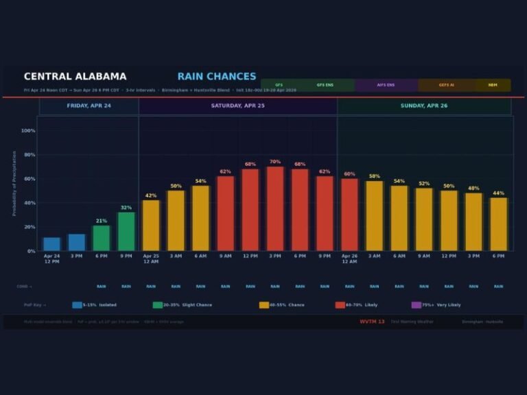
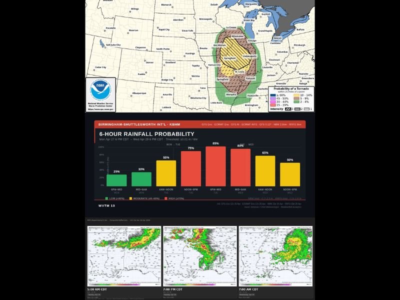
Rainfall Probability Peaks Tuesday Afternoon
Six-hour rainfall probability data shows a steadily increasing chance of precipitation across the region through the Monday-to-Wednesday period. Probabilities rise from 25 percent Monday evening to a peak of 85 percent during the Tuesday 6 PM to midnight window, before gradually tapering through Wednesday.
Total rainfall accumulations are projected between 2.7 and 2.9 inches through the period, with model guidance suggesting 1.5 to 1.6 inches as an alternate scenario. The highest rainfall concentration is expected to fall across Tuesday afternoon and evening hours.
Tuesday Afternoon Storms Bring Wind and Hail Risk
As the atmosphere reheats Tuesday afternoon, a new round of storms is expected to develop across Alabama. Strong winds and hail represent the primary hazards with this second wave, though the overall tornado risk through this period remains unlikely given available atmospheric data.
The overall setup for Alabama through April 27th points to a wind and hail driven event rather than a tornado-focused outbreak, a notably different scenario from the historical significance the late April calendar date carries for the state. For continuing coverage of severe weather events and critical storm analysis across the United States, visit SaludaStandard-Sentinel.com.