Soaking Cold Steady Rain Sweeps Across Alabama Friday Night Into Saturday Morning With Heaviest Totals Pushing South and Drought Conditions Continuing to Improve Across the Region
ALABAMA — A soaking and cold steady rain was forecast to sweep across Alabama beginning Friday late afternoon and continuing through the overnight hours into Saturday morning, delivering meaningful and drought-relieving precipitation across the state with no severe weather threat accompanying the system and heaviest rainfall totals concentrated across the southern portions of the region.
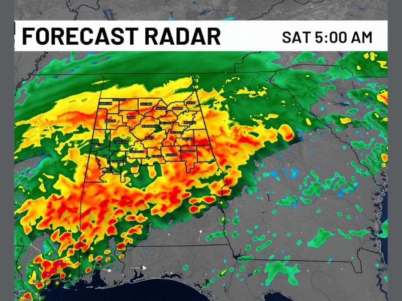
Forecast radar valid at 5:00 AM Saturday showed intense and widespread precipitation coverage blanketing the full Alabama corridor with deep orange and red returns indicating heavy rainfall pushing through the state from northwest to southeast as the cold rain event progressed through the overnight hours.
Cold Steady Rain Arrives Late Afternoon and Overnight
The rainfall event was characterized as a cold and steady rain rather than a thunderstorm-driven severe weather system, keeping the threat level manageable for residents across Alabama through the Friday night timeframe. The bulk of the precipitation was expected to arrive during the late afternoon and overnight hours, with the most significant rainfall coverage pushing through the state well into the early Saturday morning period before gradual clearing developed.
The non-severe nature of the Friday night rain event distinguished it from the active severe weather that had impacted the region through the prior week, offering communities across Alabama a more manageable but still significant precipitation event heading into the weekend.
Heaviest Rainfall Totals Concentrated Across Southern Alabama
The southern portions of Alabama were forecast to receive the heaviest rainfall accumulations from the Friday night event, with forecast radar imagery showing the most intense precipitation cores tracking through the southern tier of the state as the system pushed southeast through the overnight hours.
Communities across central and southern Alabama including Montgomery, Selma, Dothan, and surrounding areas fell within the zone of highest rainfall potential, while northern Alabama communities also received meaningful precipitation totals as the broad rain band pushed across the full state through the Saturday morning timeframe.
Drought Conditions Continue to Improve Across the Region
While the Friday night rain event was not considered a drought-busting system on its own, the week’s cumulative rainfall had made a meaningful contribution toward drought recovery across Alabama. The steady accumulation of precipitation events through the week represented a positive trend for drought-affected communities, gradually replenishing soil moisture and water resources across a state that had been dealing with dry conditions heading into the active rain pattern.
The continued improvement in drought conditions through the week of rainfall, capped by the Friday night soaking rain event, positioned Alabama for meaningful drought recovery progress even as forecasters stopped short of declaring the drought fully broken across the region.
For continuing coverage of weather events and critical storm analysis across the United States, visit SaludaStandard-Sentinel.com.