TORCON Raised to 7 Across Iowa South Dakota and Nebraska Sunday With Intense Long Lived Tornadoes Possible Late Afternoon Through Overnight as Monday Also Looks Dangerous
SIOUX CITY, IA — The Tornado Condition Index, known as TORCON, has been increased to 7 across parts of Iowa, South Dakota, and Nebraska for Sunday, placing the region at a medium to high risk for tornado activity during the late afternoon and evening hours. The TORCON scale runs from 1 to 10, with higher numbers indicating greater tornado risk, and a rating of 7 signals a serious and credible threat for intense and long lived tornadoes across the affected corridor.
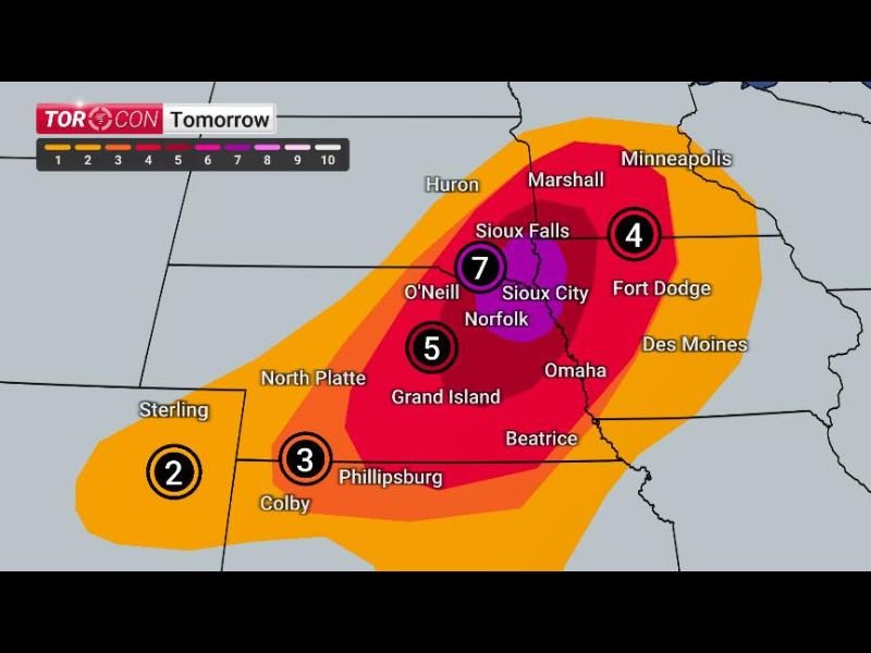
TORCON 7 Signals Medium High Tornado Risk Across Iowa South Dakota and Nebraska
The TORCON 7 designation covers a concentrated zone centered near Sioux City, Norfolk, and O’Neill, with the highest risk area depicted in deep purple on the forecast map encompassing a fairly isolated but extremely dangerous corridor across the tri-state region. Tornadoes that do develop within this TORCON 7 zone have the potential to be intense and long lived, meaning they could remain on the ground for extended distances and cause significant damage across communities in their path.
Storms are expected to fire during the late afternoon and evening hours before tracking eastward overnight, extending the tornado threat well into the nighttime hours when visibility is reduced and warning response times become more critical for residents across the affected area.
TORCON 4 to 5 Extends From Minnesota to Northern Kansas Covering a Broad Multi State Zone
Surrounding the core TORCON 7 zone, a broader medium risk area carrying TORCON values of 4 to 5 stretches from Minnesota southward through northern Kansas, covering communities including Sioux Falls, Fort Dodge, Omaha, Grand Island, and Phillipsburg. A TORCON of 4 to 5 represents a meaningful and serious tornado risk across this wider zone, with forecasters noting that many of these storms could develop and strike after dark.
Residents across the entire TORCON 4 through 7 zone from Minnesota to northern Kansas are urged to have a safe shelter location identified and ready before storms arrive, particularly given the elevated overnight tornado threat across this multi-state corridor.
Monday Also Expected to Bring Dangerous Conditions Across the Region
Beyond Sunday’s significant tornado threat, Monday is also shaping up to be a dangerous severe weather day across the region. The back to back nature of Sunday and Monday’s severe weather setups creates an extended and exhausting threat period for communities across Iowa, Nebraska, South Dakota, and surrounding states that will require sustained preparedness and weather awareness through the early part of the week.
Residents are strongly encouraged to avoid storm fatigue, monitor updated forecasts continuously, and treat every tornado warning issued during both Sunday and Monday with the highest level of urgency.
For continuing coverage of tornado risks and severe weather forecasts across the United States, visit SaludaStandard-Sentinel.com.