Intense MCS Packing 75 to 80 MPH Wind Gusts Races Through South Central and North Central Nebraska Saturday Night With Lincoln and Omaha Facing 60 to 80 MPH Gusts Through 1 AM
LINCOLN, NE — An intense Mesoscale Convective System is moving through south-central and north-central Nebraska Saturday night at 10:12 PM, generating wind gusts reaching 75 to 80 miles per hour as the destructive storm line races eastward across the state. Lincoln, Nebraska and the Omaha metro area are identified as primary areas of concern for wind gusts of 60 to 80 miles per hour through 1:00 AM as storms both ahead of and within the main MCS line continue pushing east at a rapid forward pace.
Intense MCS Producing 75 to 80 MPH Wind Gusts Across South Central Nebraska
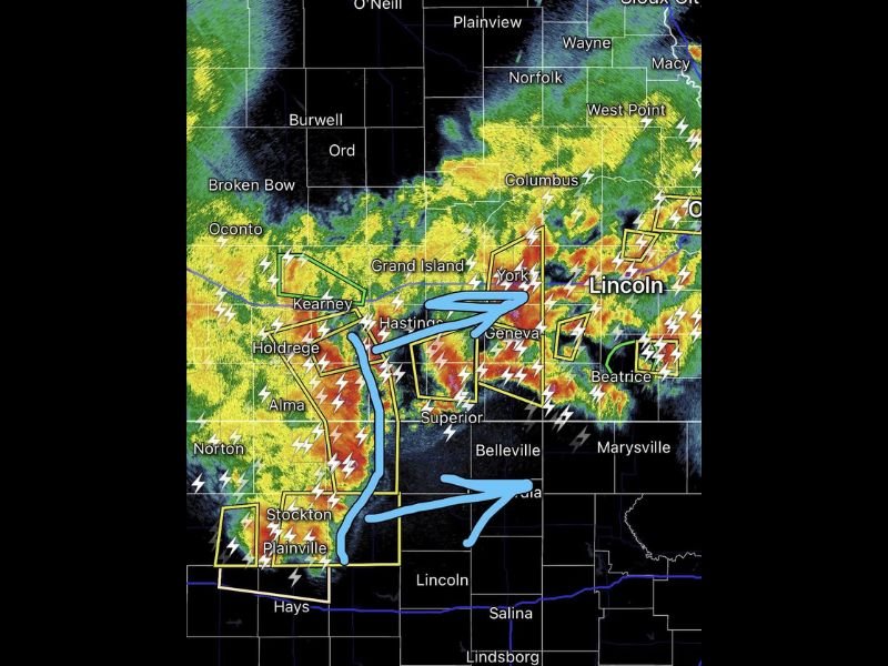
Radar imagery captured at 10:00 PM shows a broad and intense storm complex stretching across a large portion of Nebraska, with the most intense red and yellow reflectivity returns concentrated in a line running through the south-central portion of the state. Multiple active severe weather warning polygons are visible across the radar display, covering communities including Grand Island, Kearney, Hastings, York, Geneva, Beatrice, and surrounding areas as the MCS continues its rapid eastward movement through the overnight hours.
Wind gusts of 75 to 80 miles per hour are capable of causing widespread and significant structural damage, snapping trees, downing power lines, and creating dangerous conditions for any residents or motorists caught in the open as the storm line passes through the affected Nebraska corridor.
Lincoln and Omaha Face 60 to 80 MPH Wind Threat Through 1 AM
The line of intense wind gusts associated with this MCS will continue racing east over the next few hours, placing Lincoln and Omaha directly in the path of the most dangerous wind threat of the overnight event. Both cities face wind gusts of 60 to 80 miles per hour through 1:00 AM from storms both ahead of the main line and within the MCS itself, creating a prolonged and dangerous wind threat window for two of Nebraska’s most densely populated metropolitan areas.
Residents across Lincoln, Omaha, and all communities along the MCS track between Kearney and the eastern Nebraska border are urged to take immediate shelter in sturdy structures away from windows and exterior walls as the storm line approaches their areas during the overnight hours.
Rapid Eastward Movement of Storm Line Leaves Little Warning Time for Communities
The rapid forward speed of this MCS as it races eastward across Nebraska significantly compresses the warning and response time available for communities in its path. The storm line’s quick movement means conditions can deteriorate from calm to extremely dangerous within a very short window, underscoring the critical importance of having shelter plans already in place rather than waiting for conditions to worsen before taking protective action.
All residents across the affected Nebraska corridor from Grand Island eastward through Lincoln and Omaha are directed to treat this overnight MCS event with the highest level of seriousness and remain sheltered until the storm line clears their area and wind conditions return to safe levels.
For continuing coverage of severe weather events and overnight storm tracking across the United States, visit SaludaStandard-Sentinel.com.