Near Record High Temperatures Scorching North Carolina Wednesday May 20 With Readings in the 80s and 90s Statewide and Isolated Mountain Storms Possible by Late Afternoon
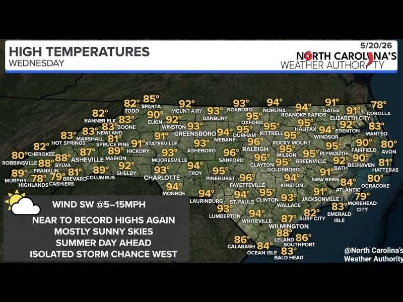
RALEIGH, NC — A hot and largely sunny Wednesday is underway across North Carolina on May 20, 2026, as high pressure maintains dominant control of the state’s weather pattern and temperatures soar into the 80s and 90s across virtually all regions. Near to record high temperatures are likely for many communities statewide as southwest winds at 5 to 15 miles per hour accompany mostly sunny skies through the afternoon, with only an isolated storm chance developing across the western mountains later in the day.
Temperatures Surge Into the Mid to Upper 90s Across Central and Eastern North Carolina
The high temperature forecast for Wednesday shows the most extreme heat concentrated across central and eastern North Carolina, with Raleigh, Mebane, Durham, and Asheboro all forecast to reach 96 degrees. Roxboro, Danbury, Oxford, and Kittrell are projected at 93 to 95 degrees, while the Greensboro, Winston-Salem, and Charlotte corridors sit in the 92 to 94 degree range through the afternoon hours.
Eastern North Carolina communities including Rocky Mount, Wilson, Kinston, Fayetteville, and surrounding areas are also forecast well into the mid 90s, reflecting the broad and intense nature of Wednesday’s heat across the central and eastern portions of the state.
Western Mountains See Cooler Readings but Face Isolated Afternoon Storm Chance
The western mountain communities of North Carolina, including Asheville, Boone, Cherokee, Murphy, and Robbinsville, see considerably cooler high temperatures ranging from the upper 70s to upper 80s compared to the sweltering readings across the central and eastern regions. However, the mountains face the one notable weather concern of the day as a few isolated showers or storms cannot be ruled out across the higher elevations during the late afternoon and evening hours.
The isolated mountain storm potential is driven by afternoon heating along the terrain rather than any organized frontal system, keeping storm coverage very limited and leaving most mountain communities dry through the day.
Weather Pattern Expected to Change for Some Areas Beginning Thursday
While Wednesday brings a summer-like and predominantly dry day across most of North Carolina, the weather pattern is expected to begin shifting for portions of the state heading into Thursday. The nature and timing of Thursday’s pattern change is expected to become clearer through additional forecast updates issued later Wednesday, with residents across the state encouraged to monitor the evolving forecast as the week progresses beyond the current heat dominated pattern.
For continuing coverage of temperature records and weather forecasts across the United States, visit SaludaStandard-Sentinel.com.