Upper Ridge Bringing Hot and Drier Days to Birmingham Alabama This Week With Highs Holding at 91 Degrees Through Friday Before Scattered Storms Return Over the Weekend
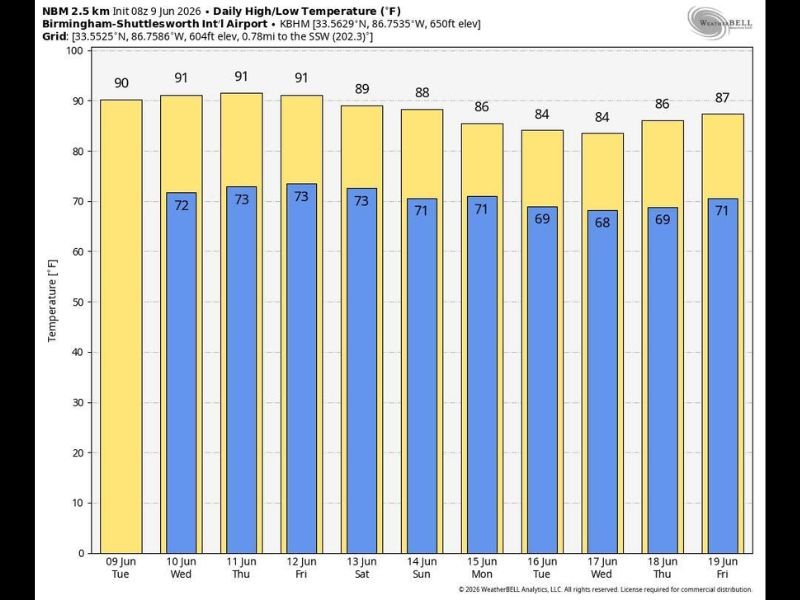
BIRMINGHAM, AL — An upper-level ridge building across the Deep South is delivering a stretch of hot, mostly dry weather to Birmingham and surrounding communities beginning Tuesday, June 9, with high temperatures forecast to hold at 90 to 91°F through Friday and only isolated afternoon and evening storm chances breaking the heat before a more active pattern develops heading into the weekend.
Tuesday Through Friday Heat Pattern
NBM 2.5 km forecast data for Birmingham-Shuttlesworth International Airport shows a remarkably consistent temperature pattern through the midweek period. Tuesday opens at 90°F before Wednesday, Thursday, and Friday all top out at 91°F — running well above normal for early June with overnight lows holding in the low 70s each night, providing minimal relief from the daytime heat accumulation.
The upper ridge suppressing storm activity will keep skies mostly sunny with only isolated shower and thunderstorm chances through the Friday timeframe. The combination of 90 to 91°F highs and elevated humidity values will make heat index readings feel considerably hotter than the actual air temperature during peak afternoon hours across the region.
Weekend Pattern Shift
Temperatures begin easing slightly heading into the weekend, with Saturday dropping to 89°F and Sunday coming in at 88°F. More importantly, the air aloft will become somewhat cooler over the weekend, increasing atmospheric instability and allowing scattered showers and thunderstorms to develop more freely — particularly during the noon to midnight window both days.
The weekend will not be a washout, but residents should be prepared for passing storm chances on both Saturday and Sunday rather than the near-complete suppression seen during the weekday period.
The Week Beyond
The upper ridge continues to gradually weaken into the following week. Highs ease further to the mid-80s between June 15 and 17 before rebounding slightly toward 86 to 87°F by the June 18 to 19 period. Overnight lows drop into the upper 60s during the mid-week cooldown, offering slightly more comfortable sleeping conditions.
Scattered to numerous daily storm chances are expected to become the norm as next week progresses and the ridge influence diminishes across the Deep South. For continuing coverage of Alabama heat and weather patterns across the United States, visit SaludaStandard-Sentinel.com.