Tornado Watch and 50 to 60 MPH Wind Gusts Threaten Northwestern Alabama With Storm Line Arriving Between 2 and 3 AM Tuesday Impacting Lauderdale Franklin and Colbert Counties
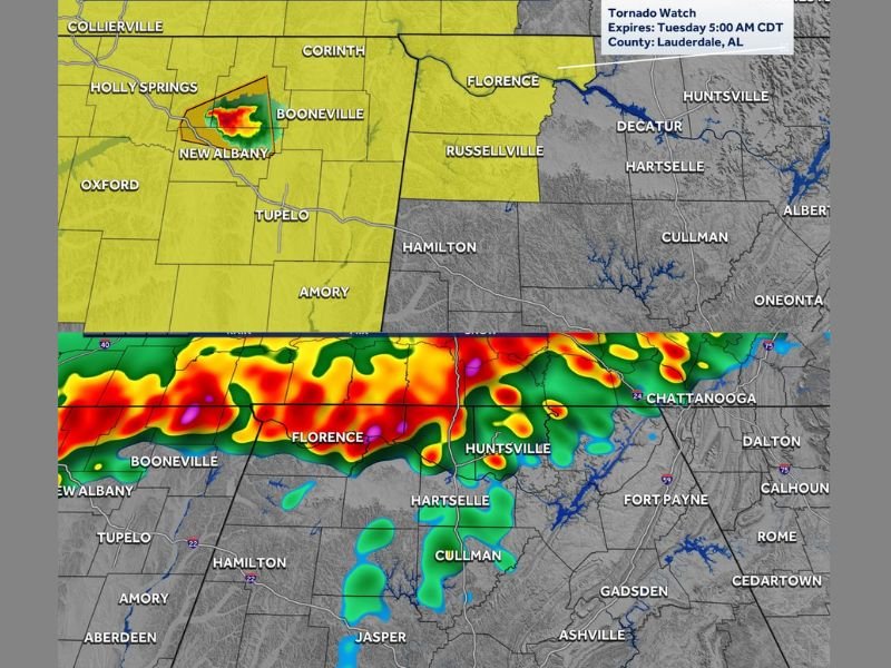
FLORENCE, AL — A Tornado Watch was placed in effect for the Shoals area of northwestern Alabama, covering Lauderdale, Franklin, and Colbert counties until 5 AM Tuesday, as a single storm was expected to move into Colbert County around midnight before a broader line of storms arrived between 2 and 3 AM.
Radar captured at 9:48 PM Monday showed active storm cells pushing toward the region from Mississippi, with the tornado watch boundary extending across a wide swath of northern Alabama including Florence, Russellville, Decatur, Hartselle, and Cullman.
Single Storm Leads Before the Line Arrives
The overnight threat developed in two distinct phases. A single storm was forecast to move into Colbert County around midnight, representing the first and more isolated hazard of the night. This initial storm carried the potential for severe weather before the main line of storms pushed into the region between 2 and 3 AM.
The line of storms arriving in the early morning hours represented the greater and more widespread threat, with 50 to 60 mile per hour wind gusts expected as the primary hazard. While not a night of widespread severe weather, any storm within the line retained the potential to briefly spin up a tornado.
Storm Timing Varies Across Northern Alabama
Futuretrack and storm timing imagery showed a clear progression of the storm system across northern Alabama through the early Tuesday morning hours. The 2 AM to 6 AM window covered Florence, Huntsville, Hartselle, and the Tennessee Valley corridor, while Birmingham, Tuscaloosa, Cullman, and surrounding central Alabama communities fell within the 4 AM to 8 AM impact window.
Further south, communities including Selma, Montgomery, Demopolis, and surrounding areas were forecast to see storm activity between 7 AM and 11 AM as the line continued its southward progression through the state.
Wind Gusts Remain the Primary Hazard
With 50 to 60 mile per hour wind gusts forecast along the storm line, the primary concern for most residents across the warned area was straight-line wind damage rather than tornado development. Gusts of this magnitude are capable of downing trees, snapping power lines, and causing structural damage to unsecured property across a wide geographic area.
While an isolated tornado within the line could not be ruled out entirely, the overall tornado threat was not expected to be widespread through the overnight and early morning hours.
Residents Advised to Stay Alert Without Losing Sleep
The severity of the overnight threat did not warrant residents staying awake through the night, provided they had a reliable method of receiving weather warnings if conditions deteriorated. Ensuring mobile weather alerts were active and a shelter plan was in place represented the appropriate level of preparation for the Monday night into Tuesday morning storm event across northwestern and northern Alabama.
For continuing coverage of severe weather events and critical storm analysis across the United States, visit SaludaStandard-Sentinel.com.