Severe Weather Risk Shifting East of I-71 Across Ohio as Rain Continues Through Miami Valley With Freezing Temperatures Expected Sunday Morning
OHIO — Good news arrived for most of Ohio Saturday morning as forecasters confirmed at 9:35 AM that the severe weather risk has shifted further east, with only those communities east of Interstate 71 facing a small and unimpressive marginal severe weather risk through the remainder of Saturday.
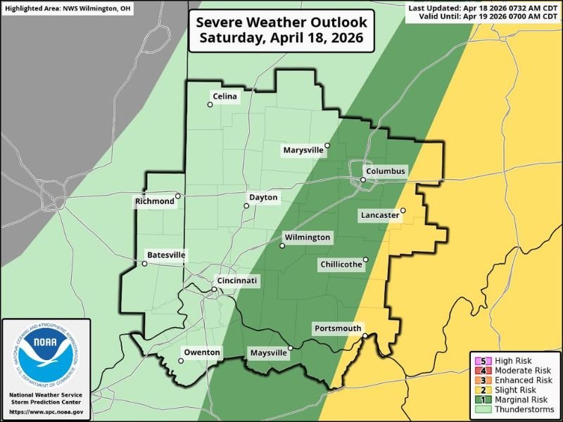
The NWS Wilmington Severe Weather Outlook valid through 7:00 AM Sunday April 19, 2026, showed a marginal risk zone covering Columbus, Lancaster, Chillicothe, Portsmouth, and Maysville while the majority of the Miami Valley and surrounding communities sit in a general thunderstorm or lower risk category.
Despite the improving severe weather picture, rain is expected to continue gradually moving through the region over the next 6 to 12 hours across the Miami Valley, and a sharp temperature drop is forecast to bring readings into the 30s by Sunday morning.
Severe Risk Limited to East of I-71 Corridor
The Severe Weather Outlook map showed the marginal risk zone concentrated east of the Interstate 71 corridor, covering communities including Columbus, Lancaster, Chillicothe, and Portsmouth in Ohio along with Maysville in Kentucky. Forecasters were clear that even this marginal risk was not looking particularly impressive, describing the setup as one that simply was not favorable for big or destructive storm development.
Communities west of Interstate 71 including Dayton, Cincinnati, Richmond, Batavia, and the broader Miami Valley region can breathe easier Saturday, as the severe weather threat for these areas has effectively passed with the main storm system pushing further east.
Rain Continues Across Miami Valley Through the Day
While the severe threat is diminishing, rain will continue gradually moving through the Miami Valley region over the next 6 to 12 hours from the time of the 9:35 AM update. Forecasters noted this will not be an all-day rain event for everyone, meaning some locations will see the rain clear earlier while others experience a more prolonged period of wet conditions through Saturday afternoon.
Residents across Dayton, Cincinnati, Wilmington, and surrounding Miami Valley communities should keep rain gear handy through the midday and early afternoon hours as the shower activity gradually exits the region from west to east.
Freezing Temperatures Arriving Sunday Morning
Perhaps the most significant weather story heading into the weekend is the sharp temperature drop expected overnight Saturday into Sunday morning. Forecasters warned that most residents across the region will wake up to temperatures in the 30s Sunday morning — a jarring contrast to the warm and stormy conditions experienced earlier this week.
Residents should protect any sensitive plants or vegetation Saturday evening before the cold arrives overnight, and ensure heating systems are functioning properly ahead of what will feel like a late-season return to winter conditions across the Ohio region.
Are you tracking Saturday’s improving weather conditions across Ohio or preparing for Sunday morning’s cold snap? Share your conditions and stay connected at SaludaStandard-Sentinel.com.