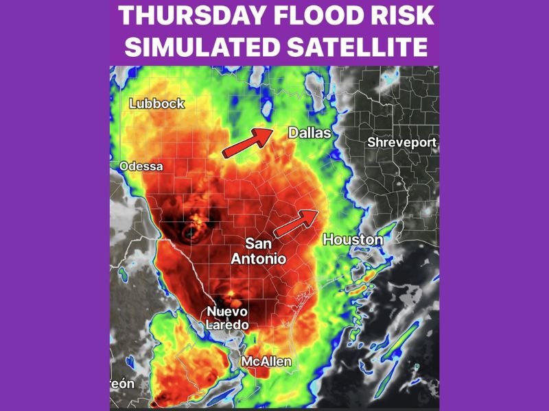
Thursday Flood Risk Targets Texas as Strong Disturbance Lifts Northeast From West Texas Through North Texas With 80 Percent Rain Coverage and 1.70 Inch Per Hour Rainfall Rates Possible
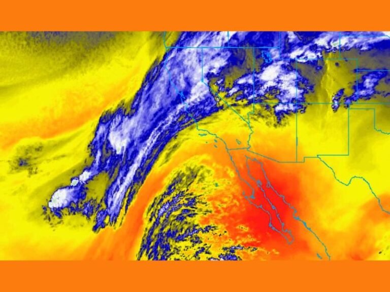
DALLAS, TX — A strong atmospheric disturbance building across West and Southwest Texas Wednesday night is forecast to lift northeast into North Texas on Thursday, bringing a significant flood risk, heavy rainfall, and an 80 percent rain coverage probability across a broad portion of the state through Thursday evening. Thursday simulated satellite imagery shows an enormous and deep moisture plume covering the majority of Texas from the Rio Grande northward through the Dallas corridor, with the heaviest precipitation potential concentrated across central and south central Texas.
Strong Disturbance Builds Wednesday Night Before Lifting Into North Texas Thursday
The disturbance initiating across West and Southwest Texas Wednesday night will serve as the primary driver of Thursday’s widespread rainfall and flood threat across the state. As the system lifts northeast through the overnight hours and into Thursday morning, moisture values across the region will increase significantly, with atmospheric water content reaching levels capable of supporting rainfall rates of 1.70 inches per hour at peak intensity across the most active portions of the storm system.
Rain is forecast to arrive Thursday morning and continue through most of the day, with coverage expected to persist until approximately sunset Thursday evening before the system gradually moves out of the region.
Flood Risk Elevated as Rainfall Rates Reach 1.70 Inches Per Hour With Slight Excessive Rain Risk
The combination of high atmospheric moisture content and rainfall rates reaching 1.70 inches per hour places a slight risk for excessive rainfall across the affected Texas corridor on Thursday. At these rainfall rates, urban drainage systems, low water crossings, and flood prone areas across Dallas, San Antonio, Houston, and surrounding communities face meaningful flash flooding potential during the most intense periods of precipitation throughout the day.
The simulated satellite imagery shows the deepest and most intense moisture signal concentrated across the San Antonio and south central Texas corridor, with the system’s northeastern lifting motion directing the heaviest rainfall potential toward the Dallas metropolitan area through the afternoon and evening hours.
80 Percent Rain Coverage Expected Across Texas Through Thursday Evening
With overall rain chances reaching 80 percent coverage across the state for most of Thursday, the vast majority of Texas communities from the Rio Grande northward through Dallas will see at least some rainfall during the day. The widespread nature of this coverage means the flood risk is not isolated to a single zone but distributed broadly across multiple Texas regions simultaneously as the disturbance lifts northeast through the state.
Residents across Dallas, San Antonio, Houston, Odessa, and all communities within the outlined moisture plume are urged to monitor flood watches and warnings closely through Thursday and avoid driving through flooded roadways as heavy rainfall impacts the region.
For continuing coverage of flood risks and storm forecasts across the United States, visit SaludaStandard-Sentinel.com.