Scattered Showers and Storms Return to Arkansas Thursday Night Through Early Friday Morning With Activity Filling in Statewide Overnight and Severe Risk Remaining Extremely Low
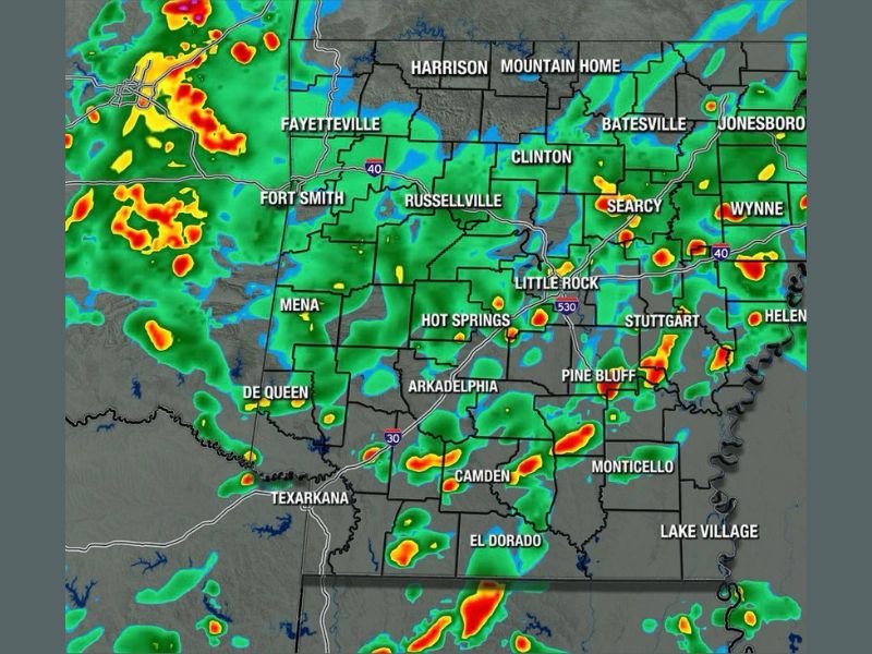
LITTLE ROCK, AR — Arkansas is set to enjoy a dry stretch through Thursday evening before scattered showers and storms fill in across the state overnight and into early Friday morning. The Arkansas Weather Network Futurecast valid for Friday at 3:00 AM shows widespread green and yellow radar returns covering a broad portion of the state, with the bulk of the rain activity holding off until after sunset Thursday before increasing through the overnight hours across all regions.
Dry Conditions Hold Through Thursday Before Rain Fills in After Sunset
The latest forecast data indicates most of Arkansas will remain dry from now through Thursday evening, with the incoming rain system holding off its main push until after sunset. Once the system begins moving in during the overnight hours, shower and storm coverage will increase significantly across the state, with higher chances for scattered activity developing through the middle of the night and continuing into the early Friday morning hours for many communities.
Some areas of Arkansas may not see any activity until the middle of the night or early Friday morning, reflecting the gradual and progressive nature of the overnight system’s movement across the state.
Isolated Spotty Activity Cannot Be Ruled Out During Thursday Daytime Hours
While the primary rain window is focused on the overnight period, isolated and spotty shower or storm activity cannot be completely ruled out across portions of Arkansas during the daytime hours on Thursday. This daytime activity would be limited in coverage and intensity compared to the more widespread overnight push, but residents should remain generally weather aware through the afternoon and evening hours as the system approaches from the west.
The Futurecast imagery shows the heaviest radar signatures concentrated across western Arkansas near Fort Smith and the Texarkana corridor, with activity spreading eastward through Little Rock, Pine Bluff, and toward the Helena and Lake Village areas through the overnight period.
Severe Weather Risk Remains Extremely Low With This Passing System
Despite the widespread coverage of showers and storms expected across Arkansas through the overnight hours, the severe weather risk associated with this particular system is considered extremely low. Residents across all regions of the state can expect primarily plain rainfall and thunder rather than any organized or significant severe weather hazard as the system passes through during the Thursday night and early Friday morning window.
Arkansas residents are encouraged to remain aware of the overnight rain timing and plan accordingly for any early Friday morning travel or outdoor activities that could be impacted by lingering shower activity as the system clears the state.
For continuing coverage of storm timing and weather forecasts across the United States, visit SaludaStandard-Sentinel.com.