Dramatic Tornado Photographed Near North Portal Saskatchewan Viewed From North Dakota as the Same Storm System Produced a Brief Tornado Earlier Near Wildrose
NORTH PORTAL, SK — A visually striking and well-developed tornado was photographed near North Portal, Saskatchewan, viewed from the northernmost road in North Dakota, as a powerful supercell produced one of the most photogenic tornado events documented across the northern Plains and Canadian border region, with the same storm system also generating a brief tornado earlier in its lifecycle near Wildrose, North Dakota.
What the Images Show
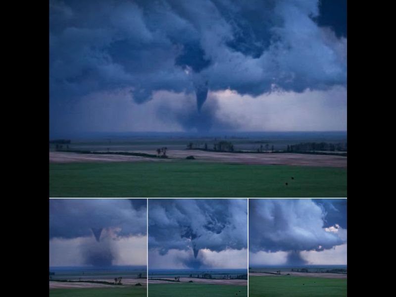
The photographs capture a classic, well-organized tornado in full contact with the ground across the flat agricultural landscape of southern Saskatchewan. The dominant image shows a distinct condensation funnel extending from a dark, turbulent cloud base to the surface, surrounded by a swirling debris and condensation field at ground level — a clear indicator of an actively occurring tornado with surface contact at the time of the photograph.
The surrounding cloud structure reveals a highly organized supercell with a broad, low-hanging base and inflow bands wrapping into the storm’s circulation from multiple directions. Three additional photographs from different angles and stages of the tornado’s lifecycle show the funnel varying in width and intensity, consistent with a tornado cycling through multiple phases of development and rope-out.
The North Dakota Connection
Before producing the Saskatchewan tornado, the same supercell generated a brief tornado near Wildrose, North Dakota, earlier in the storm’s lifecycle. This confirms the system was a long-tracked, high-performance supercell capable of producing multiple tornado events across an extended path crossing the international border — a relatively rare but meteorologically significant occurrence for the northern Plains region.
The storm was visible from the northernmost road in North Dakota, highlighting how expansive and visually dominant high-plains supercells can become when atmospheric conditions are optimally supportive across the flat terrain of the border region.
Northern Plains Tornado Climatology
Saskatchewan and the northern Plains experience tornado activity far less frequently than the traditional Tornado Alley corridor further south, making events of this visual caliber and intensity notable both scientifically and from a documentation standpoint. When supercells do develop across this region, the combination of flat terrain, sparse population, and long visibility windows can produce extraordinary photographic opportunities alongside genuine hazards for rural communities.
For continuing coverage of tornado events and severe weather across North America, visit SaludaStandard-Sentinel.com.