Heavy Rain Flash Flood Risk and 46 MPH Wind Gusts Target Alabama Wednesday Night Into Thursday Morning Across Birmingham, Jasper, Tuscaloosa, Cullman, and Gadsden
BIRMINGHAM, AL — A significant Wednesday night into Thursday morning weather event was forecast to bring heavy rain, flash flood concerns, and gusty winds up to 46 miles per hour across a broad swath of Alabama, with storms developing during the late Wednesday afternoon and early evening hours before the most impactful conditions pushed through the state overnight into Thursday morning.
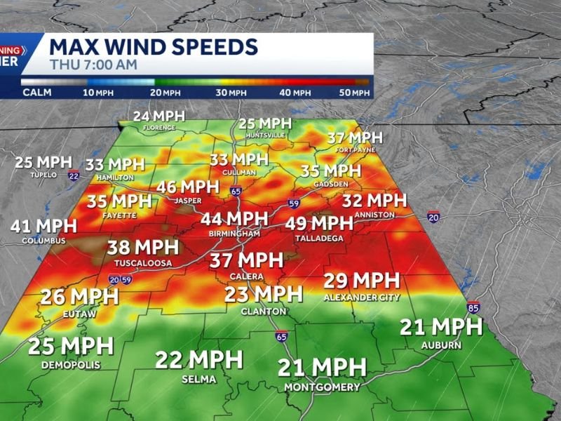
Max wind speed data valid at 7 AM Thursday showed Jasper leading the region at 46 MPH, with Birmingham at 44 MPH, Talladega at 49 MPH, Tuscaloosa at 38 MPH, Columbus at 41 MPH, Fayette at 35 MPH, Cullman and Hamilton at 33 MPH, and Gadsden at 35 MPH across the warned corridor.
Heavy Rain Remains the Primary Threat
While a few storms carried the potential for high winds, small hail, and a possible tornado late Wednesday or early Thursday, the primary threat for Alabama was identified as heavy rainfall and flash flooding rather than a widespread severe weather outbreak. Flash flood risk mapping showed a moderate risk zone concentrated across the Birmingham, Tuscaloosa, Cullman, and Lineville corridor, with a slight risk extending through Huntsville, Hamilton, Montgomery, and Clanton.
FutureCast imagery for Wednesday at 11:30 PM showed active and intense precipitation pushing through the full northern and central Alabama corridor from Florence and Huntsville southward through Birmingham, Tuscaloosa, and toward Selma and Montgomery.
Storm Timing Runs From Noon Wednesday Through 1 AM Thursday
Storm timing imagery showed northern Alabama communities including Huntsville, Fort Payne, Cullman, and Gadsden facing storm impacts between noon and 7 PM Wednesday, while Birmingham, Tuscaloosa, Jasper, and central Alabama communities were forecast to see the storm system arrive around 1 AM Thursday. Far North Alabama near US 72 also carried a morning storm chance before the main system arrived later in the day.
Residents across the full Alabama corridor were advised to remain weather aware through Wednesday afternoon and overnight as the heavy rain and wind event progressed through the state into Thursday morning.
For continuing coverage of severe weather events and critical storm analysis across the United States, visit SaludaStandard-Sentinel.com.