Damaging Wind Gusts and Hail Possible Across Ohio Under Marginal Severe Weather Risk Monday May 4 With Heavy Rain and Embedded Thunderstorms Continuing Into Tuesday
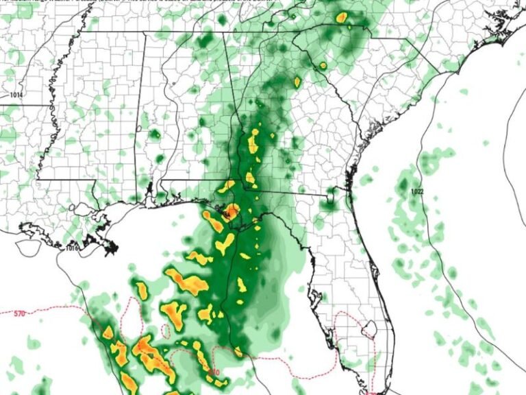
COLUMBUS, OH — A cold front approaching from the west was forecast to spark scattered showers and storms across Ohio on Monday, May 4, 2026, with a Marginal Level 1 out of 5 severe weather risk issued by the Storm Prediction Center covering a broad swath of the state including Toledo, Findlay, Dayton, Columbus, Cincinnati, and surrounding communities through the Monday evening timeframe.
Warmer and more unstable air pushing into the region Monday afternoon was expected to fuel the development of a few briefly intense storms capable of producing damaging wind gusts and some hail as the cold front pushed scattered storms toward western and northwestern Ohio during the late Monday evening hours.
Marginal Risk Covers Broad Ohio Corridor
The Severe Weather Outlook valid through May 5, 2026 at 7 AM CDT placed the majority of Ohio within the Marginal risk zone, with the slight risk designation covering the western Ohio corridor closest to the approaching cold front. Communities including Toledo, Sandusky, Cleveland, Findlay, Dayton, Columbus, Cambridge, Athens, Portsmouth, and Cincinnati all fell within the outlined risk area for the Monday severe weather event.
While the Marginal designation indicated a low overall severe weather probability, the brief intensity of individual storms developing along the frontal boundary kept damaging wind gusts and hail as real concerns for communities across western and northwestern Ohio through Monday evening.
Heavy Rain and Thunderstorms Continue Into Tuesday
Beyond the Monday severe weather window, heavy rain at times along with embedded thunderstorms was forecast to become even more likely across Ohio by late Tuesday. The severe threat was expected to remain quite limited and low during the Tuesday rain event, keeping the focus on rainfall accumulations and the general storm coverage rather than organized severe weather development through the Tuesday timeframe.
Residents across Ohio were advised to remain weather aware through the Monday evening cold front passage and into the Tuesday rain event as the active weather pattern continued through the first week of May.
For continuing coverage of severe weather events and critical storm analysis across the United States, visit SaludaStandard-Sentinel.com.