Relentless Gulf Blob Continues Pumping Heavy Rain Toward the Upper Gulf Coast Through Tuesday With Flood Outlook Expanding and Deep Tropical Moisture Targeting Florida by the Weekend
NEW ORLEANS, LA — A persistent and relentless western Gulf moisture blob is showing in full bloom on Sunday afternoon satellite imagery, continuing to pump significant rainfall northeastward toward the upper Gulf Coast as it has done consistently throughout the past week. The slow moving system off the Texas coast is expected to maintain its heavy rain producing pattern through tonight, Monday, and Tuesday before eventually sliding eastward and pulling even deeper tropical moisture northward toward Florida heading into the weekend.
Western Gulf Blob Remains in Full Bloom Pumping Heavy Rain Toward the Upper Gulf
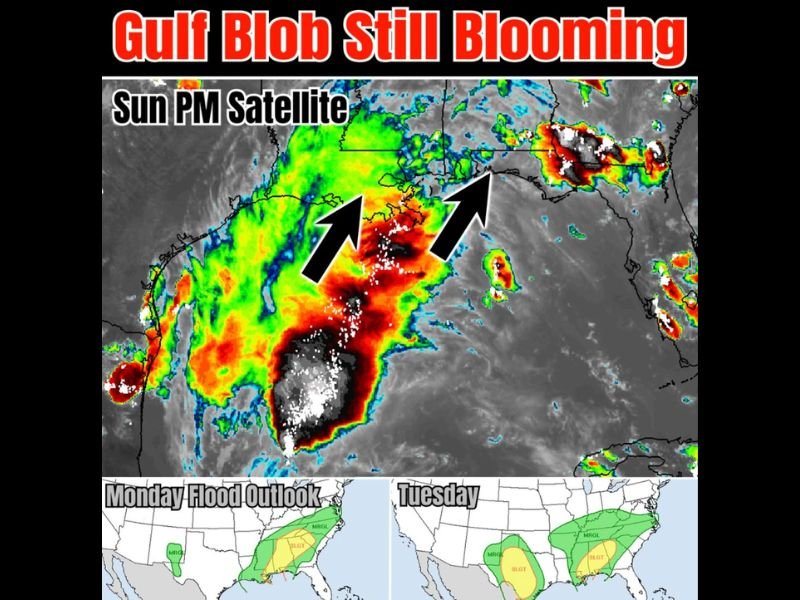
Sunday afternoon satellite imagery shows an expansive and deep moisture plume centered over the western Gulf of Mexico, with intense red and orange cloud top signatures indicating vigorous convective activity across the system. Directional arrows on the satellite imagery confirm the northeast moisture transport pathway directing the heaviest rainfall toward the upper Gulf Coast states, a pattern that has been persistent and largely stationary throughout the past week as the slow moving system repeatedly generates heavy rain across the same corridor.
The flood outlook maps for Monday show a Slight risk zone across portions of the central Gulf Coast with Marginal risk extending across a broader area, reflecting the ongoing and serious flood threat associated with the continuing moisture transport from the persistent Gulf system.
Tuesday Flood Risk Expands as System Slides East and Deepens Tropical Moisture Transport
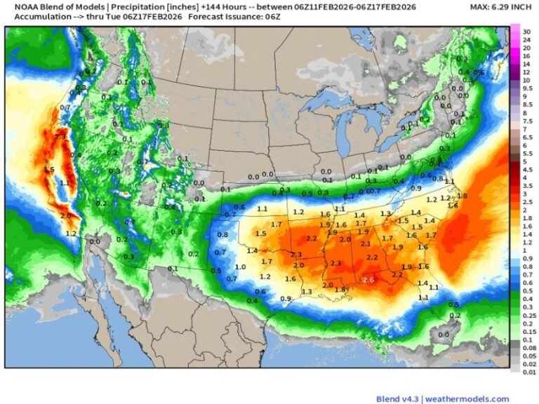
By Tuesday, the flood outlook expands considerably, with a Slight risk zone covering a larger portion of the south central United States and a Marginal risk zone extending across a broad swath from the Gulf Coast northeastward. The system’s gradual eastward slide through the week is expected to shift the heaviest rainfall focus and pull increasingly deep tropical moisture northward across a wider geographic footprint than the current pattern.
Florida Enters the Picture as Deep Tropical Moisture Targets the Peninsula This Weekend
As the Gulf system slides further east through the week, Florida moves into the picture as a target for deep tropical moisture transport heading into the weekend period. The key question for Florida’s weekend rainfall distribution centers on whether the panhandle or the peninsula receives the heaviest totals, with any low pressure development near or south of the state potentially concentrating the heaviest rains across the south and east.
For continuing coverage of Gulf moisture and flood threats across the United States, visit SaludaStandard-Sentinel.com.