Severe Threat Drops Across Upstate South Carolina and Western North Carolina as Steady Rain Replaces Storm Activity From Greenville Through Greenwood and McCormick
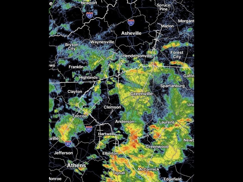
GREENVILLE, SC — The severe weather threat across Upstate South Carolina and western North Carolina has come down considerably, with current radar showing steady and widespread rain replacing the more organized and threatening storm activity that had been anticipated for the region. Radar imagery shows broad green and yellow returns covering a large zone from the Asheville and Hendersonville corridor southward through Greenville, Clemson, Anderson, and into the Greenwood and McCormick areas, with the heaviest rainfall cores concentrated across the southern end of the affected region near Greenwood, Laurens, and McCormick.
Severe Threat Diminishes as Steady Rain Dominates the Upstate South Carolina Region
The considerable reduction in the severe weather threat across Upstate South Carolina and western North Carolina reflects a less organized and less intense atmospheric setup than earlier forecasts had suggested for the region. Current radar returns show a widespread and steady rainfall pattern rather than the discrete and rotating supercell structures associated with significant severe weather, with no active signs of severe thunderstorm or tornado producing activity visible across the affected zone at the time of observation.
The transition from a potential severe weather event to a steady rain scenario provides meaningful relief for communities across the Greenville, Spartanburg, Anderson, and Clemson corridors that had been monitoring the situation closely through the day.
Heaviest Rainfall Cores Concentrate Across Greenwood Laurens and McCormick
Despite the reduced severe threat, the heaviest radar returns visible across the region are concentrated across the southern portion of the Upstate near Greenwood, Laurens, and McCormick, where red and orange reflectivity signatures indicate ongoing heavy rainfall across communities that have already received extraordinary accumulations over recent days. The continued heavy rain across this already saturated corridor raises ongoing flood concerns even without an accompanying severe weather threat, as soils across Greenwood and McCormick Counties remain fully saturated from prior storm events.
Residents Should Remain Weather Aware Despite the Reduced Severe Risk
While the severe weather threat has dropped considerably, residents across the entire affected zone from Asheville and Hendersonville southward through Greenville, Anderson, Greenwood, and McCormick are encouraged to remain weather aware through the remainder of the event. Flooding concerns persist across the most rainfall impacted communities regardless of the reduced severe weather risk, and the Turn Around Don’t Drown message remains critically important for all motorists across the region.
For continuing coverage of storm tracking and flood threats across the United States, visit SaludaStandard-Sentinel.com.