Embedded Tornadoes Damaging Winds and Hail Strike Illinois as Severe Thunderstorm Line Drops South Threatening Springfield Effingham Mt Vernon Marion and Paducah
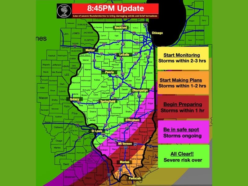
ILLINOIS — A line of severe thunderstorms was actively dropping southward across Illinois at the 8:45 PM update, bringing embedded tornadoes, damaging winds, and hail across a broad and progressing corridor that stretched from Rockford and Chicago in the north through Peoria, Springfield, Effingham, Mt. Vernon, Marion, and Paducah in the south.
Communities across the northern and central portions of Illinois had already cleared the severe threat by this point while southern Illinois remained in the active and ongoing severe weather zone, with the storm line continuing its southward push through the evening hours.
Storm Progression and Active Impact Zones
The 8:45 PM update showed a clear color-coded progression of the storm line across Illinois. Mt. Vernon, Marion, and Paducah were in the be in safe spot zone, indicating storms were actively ongoing across those communities and residents needed to remain sheltered without delay.
Effingham and surrounding south-central Illinois communities sat within the begin preparing zone, meaning storms were within one hour of arrival and immediate shelter preparations were required across that corridor.
Central Illinois Communities Within Hours of Impact
Springfield, Champaign, and surrounding central Illinois communities were placed within the start making plans zone, indicating storms were one to two hours away and residents needed to begin finalizing shelter arrangements without waiting further.
LaSalle, Peoria, and the broader central Illinois corridor sat within the start monitoring zone, with storms two to three hours from arrival and residents advised to begin actively tracking the storm line through weather alert channels.
Northern Illinois All Clear as Line Pushes South
Rockford, Moline, Quincy, and the majority of northern and western Illinois had already reached all clear status by the 8:45 PM update, with the severe risk fully over for those communities as the storm line moved away to the south and east.
Chicago and the northeastern corner of Illinois remained outside the active severe weather zone entirely, with the storm system tracking away from that region through the evening hours.
Embedded Tornadoes Remain the Critical Threat
The most significant hazard traveling with the southward dropping storm line was the continued threat for embedded tornadoes within the squall line itself. Alongside tornado potential, damaging winds and hail accompanied the line as it pushed through southern Illinois and into the Kentucky border region near Paducah.
Residents across Mt. Vernon, Marion, Paducah, and all communities still within the active and preparing zones were urged to remain in safe shelter positions until the line fully passed and an all clear was confirmed for their specific location.
For continuing coverage of severe weather events and critical storm analysis across the United States, visit SaludaStandard-Sentinel.com.