Pop-Up Pulse Thunderstorms Possible Across North and East Texas Monday Between 1 PM and 9 PM With Peak Activity From 4 to 7 PM and Highest Coverage East of Dallas
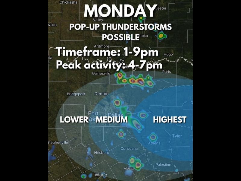
DALLAS, TX — Pop-up pulse thunderstorms are possible across North and East Texas on Monday, with the primary storm window running from 1:00 PM through 9:00 PM and peak activity expected between 4:00 PM and 7:00 PM. The highest storm coverage is forecast east of the Dallas and Fort Worth Metroplex toward the Tyler, Athens, and Palestine corridor, while the Metroplex and areas to the west face a lower to medium coverage probability through the same afternoon and evening timeframe.
Pulse Thunderstorms Expected to Develop Quickly Between 1 PM and 9 PM Monday
Monday’s storm activity will consist primarily of pulse thunderstorms, a storm type that develops rapidly and collapses back on itself quickly due to low amounts of wind shear in the atmosphere. These storms fire individually and unpredictably, making exact coverage forecasting difficult, as one storm going up can trigger a chain reaction of additional development across a broad area within a short period. The strongest pulse storms are capable of reaching marginally severe criteria, with 60 mph wind gusts and quarter sized hail possible in the most intense individual cells.
The peak activity window of 4:00 PM to 7:00 PM aligns with the period of maximum daytime heating across North Texas, when surface instability reaches its highest point and provides the greatest fuel for pulse storm development and growth across the region.
Highest Coverage East of Dallas With Lower Probability Across the Metroplex and West
The coverage probability map for Monday shows the highest storm potential concentrated east of the Dallas and Fort Worth Metroplex, with the Tyler, Athens, Corsicana, and Palestine areas facing the greatest likelihood of experiencing pulse thunderstorm activity during the afternoon and evening hours. The Metroplex itself falls within a lower to medium probability zone, while communities further west toward Bridgeport, Stephenville, and Waco carry the lowest individual storm coverage probability of the day.
Heavy Rain and Lightning Remain the Primary Hazards With Marginal Severe Possible
While the overall severe weather threat with Monday’s pulse storm setup remains low, heavy rain and frequent lightning represent the primary hazards associated with any storm cells that develop across North and East Texas through the afternoon. Residents across the entire outlined coverage area are encouraged to remain weather aware through the 9:00 PM end of the storm window.
For continuing coverage of storm forecasts across the United States, visit SaludaStandard-Sentinel.com.