Two Potential Frost Events Threaten the Northeast With Below 40 Degree Temperatures Forecast Friday Morning and Again Sunday Morning Across the Region
NORTHEAST US — Two separate potential frost events were forecast to impact the northeastern United States, with the first arriving Friday morning, May 1, 2026, and the second following on Sunday morning, as ECMWF ensemble model data showed probabilities of temperatures dropping to or below 40 degrees Fahrenheit across a significant portion of the Northeast corridor.
The good news within the forecast was that the frost threat was not as widespread as initially anticipated, with cloud cover expected to limit how cold temperatures ultimately dropped during both potential frost events across the affected region.
Friday Morning Brings the First Frost Threat
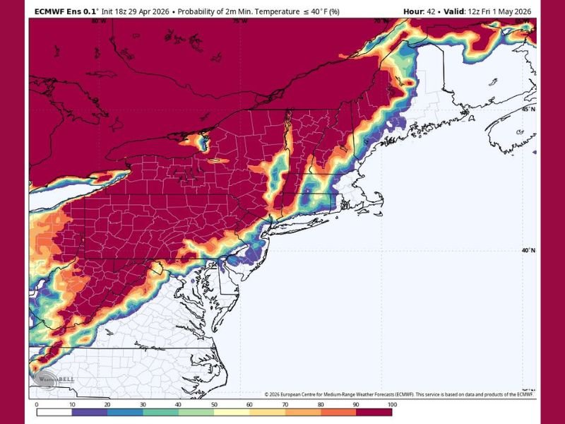
ECMWF ensemble model data valid at 12Z Friday, May 1, 2026 showed elevated probabilities of minimum temperatures reaching at or below 40 degrees Fahrenheit across interior portions of the Northeast. The highest probability zones were concentrated across northern and interior New England, upstate New York, and elevated terrain corridors running through Pennsylvania and the Appalachian region.
Coastal areas and more densely populated urban zones along the Eastern Seaboard showed lower frost probabilities, consistent with the moderating influence of proximity to the Atlantic Ocean and urban heat island effects that typically keep coastal temperatures above the most critical thresholds during marginal frost events.
Cloud Cover Limits the Severity of Both Events
A key mitigating factor for both the Friday and Sunday morning frost events was the anticipated presence of cloud cover across portions of the region. Clouds act as an insulating blanket during overnight hours, trapping surface warmth and preventing temperatures from dropping as sharply as they would under clear sky conditions.
The combination of cloud coverage and the less widespread nature of the cold air intrusion compared to initial model projections pointed to a frost threat that, while real and worth monitoring for sensitive vegetation and agriculture, was not expected to produce the most extreme or damaging cold temperatures across the full Northeast region.
Sunday Morning Brings a Second Round of Cold
Following the Friday morning frost event, a second potential frost opportunity was identified for Sunday morning across the Northeast. The back-to-back nature of the two cold events within the same weekend period raised concern for agricultural interests, gardeners, and communities with sensitive vegetation that could sustain damage from consecutive nights of near or below freezing surface temperatures.
The Sunday morning event, like Friday, carried the potential for temperatures to drop toward or below 40 degrees across interior and elevated portions of the Northeast, with the full extent and severity of the second event dependent on cloud coverage and the precise track of the cold air mass through the region.
For continuing coverage of weather events and critical storm analysis across the United States, visit SaludaStandard-Sentinel.com.