Extreme Three Hour Rainfall Totals Exceed 4 to 6 Inches Across the Tampa Bay Region Tuesday Evening With Localized Flooding Concerns From Clearwater Through North Tampa
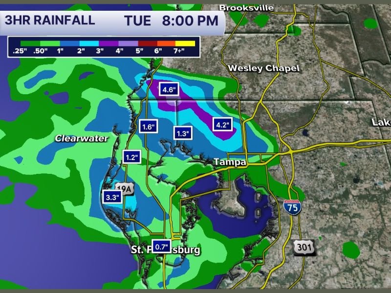
TAMPA, FL — An extraordinary three hour rainfall event has impacted the Tampa Bay region through Tuesday evening, with radar estimated accumulations reaching 4.6 inches north of Tampa and 4.2 inches across the northeast Tampa corridor as of the 8:00 PM snapshot. The three hour rainfall map issued by Tampa Bay Weather shows purple shading concentrated over a focused zone north of Tampa indicating totals in the 5 to 7 inch plus range, representing exceptional precipitation rates for even the most rainfall active region in the continental United States.
Three Hour Rainfall Totals of 4 to 6 Inches Concentrated North of Tampa
The highest three hour rainfall totals on the 8:00 PM map are concentrated in a focused purple and dark blue zone positioned north of Tampa near the Wesley Chapel corridor, with individual point totals of 4.6 inches and 4.2 inches documented across that zone within the three hour window. These accumulation rates, if sustained across a short period, are capable of producing rapid and significant flash flooding across roadways, low lying neighborhoods, and areas with poor drainage infrastructure throughout the affected zone.
Clearwater and the surrounding Gulf Coast communities show three hour totals ranging from 1.2 to 3.3 inches across a broad swath, reflecting the wide geographic footprint of the rainfall event across the entire Tampa Bay metropolitan region during the Tuesday evening hours.
Localized Flash Flooding Threat Elevated Across the Most Impacted Zones
Rainfall accumulations of 4 to 6 inches within a three hour window represent a serious and acute flash flooding threat for communities across the north Tampa and Wesley Chapel corridors where the highest totals were recorded. Streets, underpasses, and low water crossings across these zones are at significant risk of becoming impassable during and immediately following rainfall events of this magnitude, creating dangerous driving conditions for motorists throughout the affected area.
St. Petersburg recorded comparatively lighter totals of 0.7 inches over the same three hour period, reflecting the highly localized and concentrated nature of the heaviest rainfall cells within the broader Tampa Bay storm event Tuesday evening.
Tampa Bay Region Residents Urged to Avoid Flood Prone Areas Through the Evening
All residents across the Tampa Bay region, and particularly those in and around the north Tampa, Clearwater, and Wesley Chapel corridors where the heaviest three hour totals were recorded, are strongly urged to avoid driving through standing water on roadways and to stay away from flood prone low lying areas through the remainder of the Tuesday evening hours.
Turn around do not drown remains the critical safety message for all motorists encountering flooded roadways across the Tampa Bay region as the heavy rainfall event continues to impact the area. For continuing coverage of flash flooding and severe weather events across the United States, visit SaludaStandard-Sentinel.com.