Severe Thunderstorm Warning Issued for Bexar Kendall Comal and Bandera Counties Texas With 60 MPH Wind Gusts Small Hail and Torrential Rainfall Moving East Southeast Through San Antonio
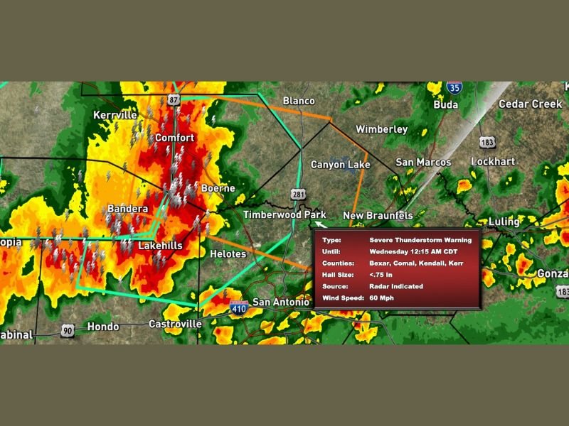
SAN ANTONIO, TX — A severe thunderstorm warning has been issued for Bexar, Kendall, Comal, and eastern Bandera County in Texas, valid through Wednesday at 12:15 AM CDT, as a powerful storm line packing 60 miles per hour wind gusts, small hail, and torrential rainfall moves east-southeast through the region. Live Power Doppler radar captured at 11:20 PM Tuesday shows intense red and deep reflectivity returns concentrated across the warning zone, with widespread lightning activity covering the Comfort, Boerne, Bandera, and Lakehills corridors as the storm pushes toward San Antonio.
60 MPH Wind Gusts and Small Hail Confirmed Across the Warning Zone
The severe thunderstorm warning covers Bexar, Comal, Kendall, and Kerr Counties with a radar indicated source and confirmed wind speeds of 60 miles per hour associated with the advancing storm line. Wind gusts exceeding 60 miles per hour have already been reported within this line, confirming the destructive wind potential as the storm continues its east-southeast movement toward the San Antonio metropolitan area and surrounding Hill Country communities.
Hail sizes up to 0.75 inches have been associated with this storm system, capable of causing minor damage to vehicles and property across the affected counties as the line pushes through the region during the late night hours.
Torrential Rainfall and Intense Lightning Accompany the Advancing Storm Line
Beyond the wind and hail threats, torrential rainfall is occurring within the storm line as it moves through Kendall and Bexar Counties toward San Antonio. The radar imagery shows extremely dense reflectivity returns across the Comfort, Boerne, and Bandera areas, consistent with very heavy and potentially flooding rainfall rates beneath the most intense portions of the storm core as it advances east-southeast through the Texas Hill Country.
Widespread and frequent lightning activity is visible across the entire warning zone on radar, with lightning bolt signatures concentrated heavily across the Bandera, Lakehills, and Boerne corridors as the storm system continues its progression toward New Braunfels, San Marcos, and the broader San Antonio metro area.
San Antonio and Surrounding Communities Face Imminent Storm Arrival
The east-southeast track of this severe thunderstorm warning places the San Antonio metropolitan area, including communities along Interstate 410 and surrounding neighborhoods, directly in the path of the advancing storm line. New Braunfels, Helotes, Castroville, and surrounding communities also fall within the threat zone as the storm continues moving through the region toward the Wednesday 12:15 AM CDT warning expiration time.
All residents across Bexar, Kendall, Comal, and eastern Bandera County are urged to remain indoors, away from windows, and monitor official weather updates continuously until the severe thunderstorm warning expires and the storm fully clears their area.
For continuing coverage of severe thunderstorm warnings and storm tracking across the United States, visit SaludaStandard-Sentinel.com.