Flooding Threat and Tornado Watch Overnight Target Alabama and North Central Mississippi With 3 to 5 Inches of Rain Impacting Birmingham, Florence, Tuscaloosa, and Montgomery
BIRMINGHAM, AL — A Tornado Watch was placed into effect for North and Central Mississippi through the overnight hours as a complex and dangerous weather system pushed through Alabama and surrounding states, with flooding emerging as the most significant threat for Alabama where short-range guidance indicated 3 to 5 additional inches of rainfall on top of precipitation already received through Tuesday evening.
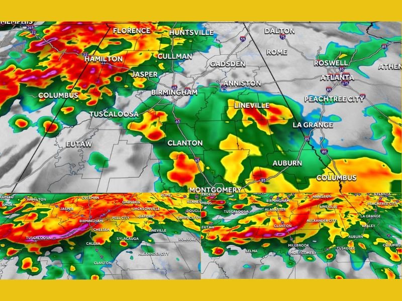
FutureCast imagery captured at 11 PM Tuesday, 4:30 AM Wednesday, and 6 AM Wednesday showed the storm system maintaining a persistent and organized presence across northern and central Alabama through the overnight and early morning hours, with intense precipitation cores tracking through Florence, Hamilton, Jasper, Birmingham, Tuscaloosa, Cullman, Gadsden, and Montgomery.
Flooding Identified as Alabama’s Greatest Overnight Concern
While the tornado threat for Alabama remained limited overnight due to insufficient atmospheric instability to support big-time severe weather development, flooding was identified as the primary and most dangerous hazard facing the state. Short-range model guidance indicated 3 to 5 inches of additional rainfall accumulating on top of precipitation already received, creating conditions highly favorable for flash flooding across low-lying areas, roadways, and drainage systems throughout Alabama.
Residents across the warned corridor were advised to be on alert for flooding conditions developing through the overnight hours and into the Wednesday morning commute window.
Limited But Nonzero Severe Weather Chance Remains
Despite the overall severe weather instability falling short of supporting widespread tornado development across Alabama, a limited chance remained for one or two overnight storms to produce tree-damaging winds, lightning-related power outages, and localized wind damage across the state. The possibility, while not the primary concern, was sufficient to warrant continued weather awareness for residents across northern and central Alabama through the overnight period.
The Tornado Watch issued for North and Central Mississippi reflected the more favorable severe weather environment present further west, where atmospheric instability was more supportive of significant storm development through the night.
Storm System Tracks Through Alabama Into Wednesday Morning
FutureCast progression showed the storm system maintaining coverage across Alabama from the 11 PM Tuesday timeframe through the 4:30 AM and 6 AM Wednesday frames, with intense precipitation continuing to push through Birmingham, Tuscaloosa, Clanton, Montgomery, Auburn, and surrounding communities well into the early morning hours.
The persistent nature of the rainfall through the overnight and morning period was the key driver behind the escalating flooding concern, as continuous heavy rain over already saturated ground created increasingly dangerous runoff and flash flood potential across the state heading into Wednesday morning.
For continuing coverage of severe weather events and critical storm analysis across the United States, visit SaludaStandard-Sentinel.com.