Temperatures to Plunge 10 to 20 Degrees Below Normal Across Texas, Oklahoma, Kansas, Missouri and Eastern US as May Starts Chilly With Highs in the 60s and Lows in the 40s
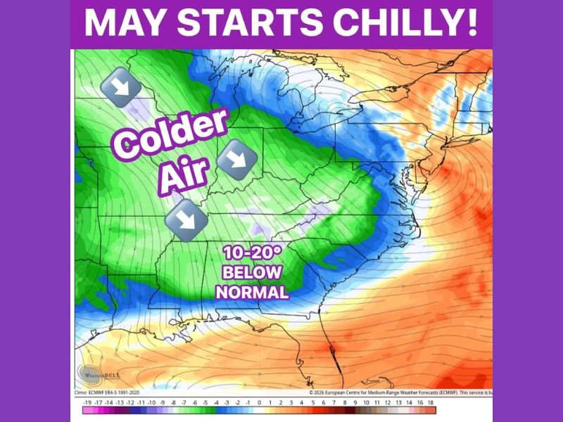
CENTRAL AND EASTERN UNITED STATES — May is not arriving with warmth this year. Multiple weather models are consistently trending cooler for the start of the month, with signals strengthening for temperatures running 10 to 20 degrees below normal as the calendar flips to May across a broad swath of the central and eastern United States.
That would translate to daytime highs stuck in the 60s and overnight lows dropping into the 40s for several consecutive days, a pattern that will feel dramatically different from what much of the country experienced during the warm stretch earlier in April. The ECMWF forecast map confirms a large dome of colder air pushing southeastward from Canada, covering the central Plains, Midwest, and a significant portion of the eastern United States under well-below-normal temperature anomalies.
Highs in the 60s and Lows in the 40s for Several Days
The practical impact of this cold pattern for residents across the affected region will be noticeable and sustained. Daytime high temperatures expected in the 60s represent a sharp departure from seasonal norms for early May, when many areas across the central and eastern US would typically be seeing highs well into the 70s and even approaching the 80s.
Overnight lows falling into the 40s will add an additional layer of chill, particularly for areas that had recently begun transitioning into warmer spring routines. Residents who have already planted spring gardens or put away cold-weather gear may need to revisit those decisions as this chilly pattern takes hold.
Rain Possible as the Pattern Brings Moisture
One notable silver lining accompanying this cold pattern is the potential for meaningful rainfall across portions of the affected region. Forecasters note that the cooler setup could finally bring some rain with it, which would be welcome news for areas across the South and Southeast that have been battling historic drought conditions in recent weeks.
After an extended period of dry and warm conditions that pushed drought levels to record extremes across parts of the Southeast, any significant rainfall associated with this early May pattern would offer at least partial relief to parched soils and stressed vegetation across the region.
Western US Remains Well Above Normal
While the central and eastern United States braces for a chilly start to May, the western US is experiencing the opposite extreme. The ECMWF anomaly map shows deep orange and red coverage across the West, indicating temperatures running well above normal from the Southwest through the Pacific coast states during the same period.
This sharp east-west temperature contrast is a hallmark of the large-scale atmospheric pattern driving the cold air push into the central and eastern US, and it reinforces the idea that this early May chill is driven by a significant and organized atmospheric setup rather than a brief or minor temperature fluctuation.
Are you ready for a chilly start to May? Share your thoughts and stay informed at SaludaStandard-Sentinel.com.