Showers and Thunderstorms to Strike North Texas Before Sunrise Tuesday, Dallas, Wichita Falls and Surrounding Areas Face 70% Coverage With Up to 1 Inch of Rain From 6AM to 3PM
NORTH TEXAS — A weather disturbance building overnight is set to arrive across North Texas before sunrise Tuesday morning, bringing a widespread round of showers and isolated thunderstorms to the region. The active window is forecast to run from 6AM through 3PM Tuesday, giving residents a prolonged period of unsettled weather to navigate through the morning and into the early afternoon hours. Overall storm coverage is expected to reach 70%, meaning the large majority of the region will see measurable rainfall before the system clears out.
Rainfall totals from this system are expected to come in at 0.50 to 1.00 inches across most of the affected area, with isolated higher totals possible in spots where the heaviest cells train over the same location.
Disturbance Arrives Before Sunrise Across the Region
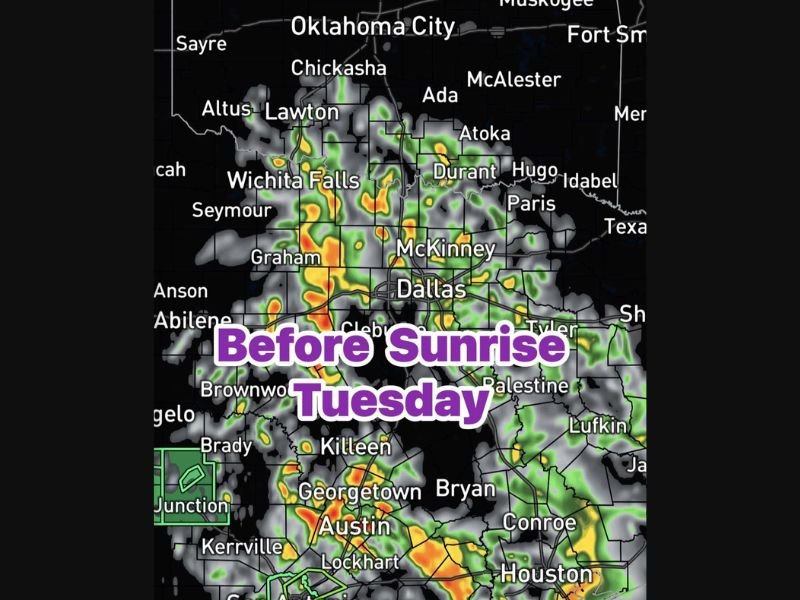
The overnight build of this disturbance means many North Texas residents will wake up Tuesday morning to already-wet conditions across the area. Radar imagery shows the precipitation footprint covering a broad swath of North Texas stretching from Wichita Falls and Graham in the northwest through the Dallas and McKinney corridor and extending southward toward Austin, Killeen, and the Georgetown area.
Communities including Wichita Falls, Seymour, Graham, Lawton, Durant, McKinney, Dallas, Cleburne, Brownwood, Killeen, Georgetown, and Austin all fall within the active rainfall zone for Tuesday morning.
Active Window Runs 6AM Through 3PM Tuesday
The primary window for showers and isolated thunderstorm activity is forecast from 6AM through 3PM Tuesday, placing the heart of the event squarely during the morning commute and midday hours. With 70% storm coverage expected across the region, most North Texas commuters heading out during the morning rush hour should plan for wet roads, reduced visibility, and potential lightning activity in their area.
Isolated thunderstorms within the broader rain shield could produce locally heavier downpours, brief gusty winds, and frequent lightning during the most active periods of the morning.
Rainfall Totals and Commute Impacts
Most locations across North Texas should see between 0.50 and 1.00 inches of rainfall from this system, a meaningful but manageable total under normal circumstances. However, areas that are already carrying elevated soil moisture from recent rainfall events could see localized ponding and minor flooding in low-lying areas if the heavier isolated cells park over the same locations.
Drivers heading out during Tuesday morning should allow extra travel time, increase following distances, and use headlights throughout the commute window. Conditions are expected to gradually improve through the afternoon as the system pushes eastward and coverage decreases after 3PM.
Are you dealing with the Tuesday morning storms across North Texas? Share your experience and stay informed at SaludaStandard-Sentinel.com.