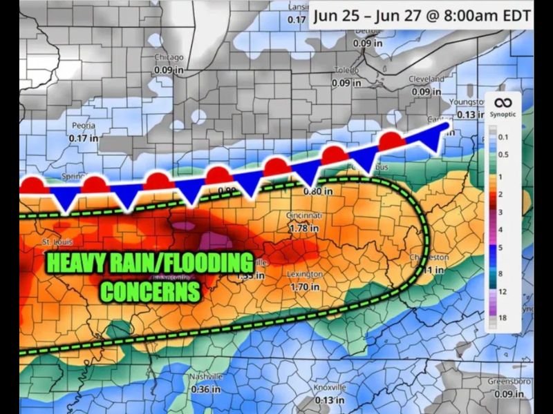
Heavy Rain and Flash Flooding Concerns Target Ohio Valley Thursday Night Through Friday as Stationary Boundary Drops 3 to 4 Inches Near Cincinnati and Lexington
CINCINNATI, OH — A stationary frontal boundary setting up across the Ohio Valley late Thursday through Friday will trigger numerous rounds of heavy rain and elevated storm risks, with simulated rainfall totals showing widespread accumulations of 1 inch or more across the region and localized totals approaching 3 to 4 inches near Cincinnati, Lexington, and Charleston as flooding and flash flooding concerns mount.
Stationary Boundary Drives Repeated Rainfall Rounds
The primary driver of this heavy rain event is a stationary boundary that will remain anchored across the Ohio Valley from late Thursday night through Friday night, allowing repeated rounds of heavy rainfall to develop and track over the same communities during the 48-hour period. This type of setup is particularly dangerous from a flooding perspective, as the same areas receive rainfall repeatedly rather than any single storm system moving through quickly.
Rainfall simulations covering the period from 8 AM Thursday June 25 through 8 AM Saturday June 27 show the heaviest totals concentrated along and south of the stationary boundary, with the highest accumulations focused across Kentucky, southern Ohio, and West Virginia.
Heaviest Totals Centered on the Kentucky Ohio Corridor
Simulated rainfall totals highlight Cincinnati at 1.78 inches, Lexington at 1.70 inches, and Charleston at over 1 inch as the most directly impacted communities within the heaviest rainfall corridor. Areas just north of the boundary, including Columbus at 0.80 inches and Youngstown at 0.13 inches, will see considerably lower totals as the boundary keeps the heaviest rain focused to the south.
Cities farther north including Chicago, Toledo, and Cleveland are expected to see only minimal accumulations of around 0.09 inches, remaining largely outside the primary heavy rain zone through the event.
Flooding and Flash Flooding Must Be Monitored
Forecasters specifically flagged flooding and flash flooding as concerns that will need careful monitoring throughout the Thursday night into Friday night timeframe. With localized totals potentially approaching 3 to 4 inches across the most heavily impacted zones, rapid water rises on area roads and streams are possible, particularly in communities that have already seen recent rainfall and carry elevated soil moisture heading into the event.
For continuing coverage of flooding threats and heavy rain events across the United States, visit SaludaStandard-Sentinel.com.