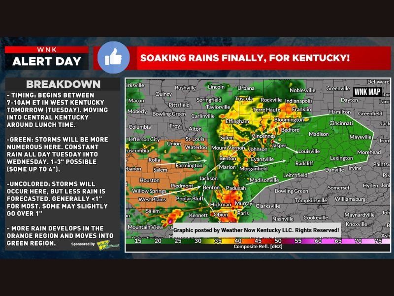
Soaking Rains of 1 to 4 Inches and Isolated Flash Flood Risk Hit Kentucky Tuesday With Storms Beginning in West Kentucky at 7 AM Moving Into Central Kentucky by Lunch
KENTUCKY — A significant and much-needed soaking rain event was forecast to sweep across Kentucky on Tuesday, delivering 1 to 3 inches of rainfall across the green region with some spots reaching up to 4 inches as constant rain persisted throughout Tuesday and into Wednesday, while no real severe weather risks were anticipated with the system beyond an isolated flash flooding concern across the heavier rainfall zones.
Storm timing showed the rain beginning across western Kentucky between 7 and 10 AM Tuesday before moving into central Kentucky around the lunch hour, with the broader precipitation footprint expanding across the state through the afternoon and evening hours.
Western Kentucky Gets the Heaviest Rain
The green zone across western and central Kentucky was forecast to see the most significant and persistent rainfall from the Tuesday system, with constant rain expected throughout the day and into Wednesday delivering totals between 1 and 3 inches with isolated spots potentially reaching 4 inches. The consistent and prolonged nature of the rainfall across the green zone elevated the isolated flash flooding concern for low-lying areas and poor-drainage communities within that corridor.
Paducah, Murray, Madisonville, Bowling Green, and surrounding western and central Kentucky communities fell within the primary rainfall zone, with the heaviest totals accumulating through the sustained Tuesday into Wednesday precipitation period.
Lighter Rain Expected Across Remaining Kentucky Areas
Outside the primary green zone, storms were still expected across the broader Kentucky region but with generally lighter accumulations of under one inch for most locations. Some communities in this outer zone may have slightly exceeded one inch depending on storm placement, but the overall rainfall footprint remained less impactful than the western and central Kentucky corridor receiving the heaviest and most sustained precipitation.
With no significant severe weather risks accompanying the system, the Tuesday Kentucky rain event was primarily a beneficial soaking rainfall event for a state that welcomed the precipitation heading into the mid-week period.
For continuing coverage of weather events and critical storm analysis across the United States, visit SaludaStandard-Sentinel.com.