Loaded Tornado Parameters and Non-Zero Tornado Risk Target the Gulf Coast and Deep South Wednesday Night With Discrete Storms Possible During Prime Evening Into Overnight Window
GULF COAST — A heavily loaded atmospheric setup was building across the Gulf Coast and Deep South for Wednesday night, with tornado parameters reaching dangerous levels and a non-zero tornado risk confirmed for the evening into overnight prime window as discrete storms remained possible across a broad corridor stretching from the Gulf Coast through Mississippi, Alabama, and into Tennessee and the Carolinas.
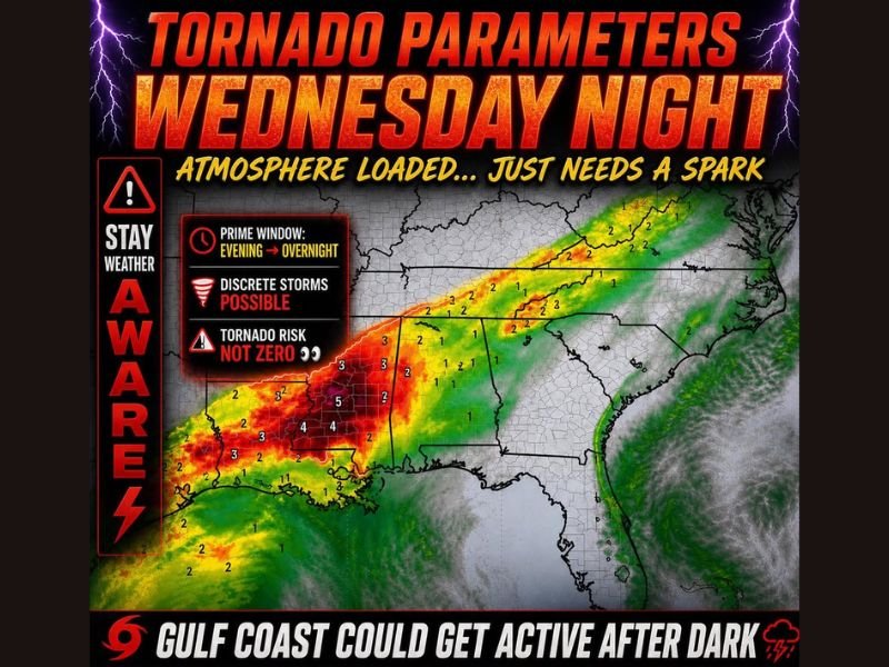
The tornado parameter map showed values reaching 4 and 5 across the core Gulf Coast zone, with significant severe weather parameter values of 2 and 3 extending through Mississippi, Alabama, and northward through Tennessee and into the mid-Atlantic states, confirming a loaded atmosphere that needed only a triggering spark to produce dangerous storm activity after dark.
Atmosphere Loaded and Waiting for a Spark
The Wednesday night setup was characterized by an atmosphere fully primed for tornado-capable storm development but dependent on a triggering mechanism to initiate discrete storm activity across the Gulf Coast region. The prime window for the most dangerous storm development was identified as the evening into overnight hours, making the Wednesday night timeframe particularly dangerous as reduced visibility would limit residents’ ability to visually identify approaching storms.
Discrete storms breaking out within this loaded environment carried the potential to rapidly organize and produce tornadoes, large hail, and damaging winds across communities positioned within the highest parameter zones along the Gulf Coast corridor.
Gulf Coast Could Get Active After Dark
The Gulf Coast region was specifically flagged as an area that could become significantly active after dark on Wednesday night, with the highest tornado parameter values concentrated across the coastal Mississippi, Louisiana, and Alabama corridor. The combination of maximum tornado parameters, a loaded atmosphere, and nighttime timing created a particularly hazardous scenario for Gulf Coast communities heading into Wednesday evening.
Residents across the full warned corridor from the Gulf Coast through Mississippi, Alabama, Tennessee, and the Carolinas were urged to know their safe shelter location, keep weather alerts loud enough to wake them from sleep, ensure phones were fully charged, and have shoes and a plan ready for immediate execution if tornado warnings were issued through the Wednesday night into Thursday morning timeframe.
For continuing coverage of severe weather events and critical storm analysis across the United States, visit SaludaStandard-Sentinel.com.