Severe Thunderstorm Warning Issued for Central North Carolina Counties With 60 MPH Wind Gusts Threatening Sanford Pinehurst and Southern Pines
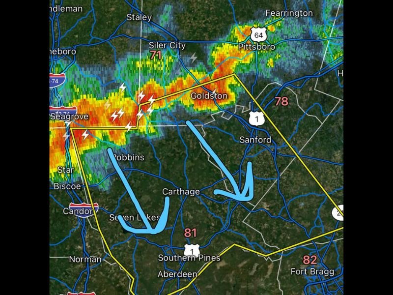
SANFORD, NC — The National Weather Service issued a Severe Thunderstorm Warning for multiple central North Carolina counties Wednesday evening after a radar-confirmed severe thunderstorm capable of producing 60 mile per hour wind gusts was located between Robbins and approximately five miles northwest of Sanford, moving southeast at 30 miles per hour with the warning valid until 9:15 PM EDT.
Counties and Communities Under the Warning
The warning encompassed Moore County, southwestern Harnett County, Lee County, and southwestern Chatham County across central North Carolina, capturing a densely populated corridor of communities within its boundaries.
Specific locations identified as directly impacted include Sanford, Southern Pines, Carthage, Pinehurst, Aberdeen, Goldston, Whispering Pines, Pinebluff, Robbins, and Foxfire, along with US Route 1 between Mile Markers 69 and 73, placing a significant stretch of a major travel corridor within the active threat zone during the warning period.
Primary Hazard and Expected Damage
The sole designated hazard for this severe thunderstorm warning is wind gusts reaching 60 miles per hour, a threshold capable of producing meaningful structural and property damage across the warned area without any tornado activity required to generate significant impacts.
At 60 miles per hour, wind gusts are strong enough to damage roof coverings and siding on homes and businesses, snap tree limbs and topple weaker trees entirely, and send unsecured outdoor objects airborne as dangerous projectiles. Power outages across portions of the warned counties were a likely consequence of the storm’s passage through the region.
Storm Movement and Radar Presentation
Radar imagery at the time of the warning shows a well-organized and intense storm core displaying deep red and orange reflectivity values moving through the Seagrove and Robbins area and tracking toward the Sanford and Carthage corridor at its reported 30 mile per hour southeastward pace.
The warning polygon captured a broad swath of central North Carolina real estate, reflecting forecaster confidence that the storm’s damaging wind potential extended across the full geographic area encompassed by the issued boundaries.
Safety Actions for Residents
Residents within the warned counties were urged to move indoors immediately, stay away from windows, and secure or bring inside any loose outdoor furniture, decorations, or equipment that could become hazardous under the forecast wind conditions until the storm cleared the area before the 9:15 PM expiration.
For continuing coverage of severe weather warnings and storm impacts across the United States, visit SaludaStandard-Sentinel.com.