Beneficial Rain Soaks South Carolina Friday From Columbia to Florence as Isolated Storms With Low Severe Risk Hold Near Horry County Coast
MYRTLE BEACH, SC — A Friday morning radar update showed widespread but largely beneficial rainfall spreading across South Carolina, with the only thunderstorm activity confined to Horry County along the coast, where the overall severe weather risk remained very low through the early morning hours.
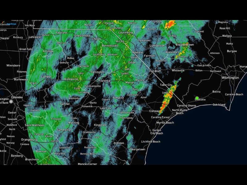
Statewide Rain Coverage Without Major Concerns
As of 6:40 AM, radar showed a broad shield of light to moderate rain extending across much of the Pee Dee and Midlands regions, including Florence, Darlington, Sumter, and Columbia. The widespread coverage was producing steady rainfall rather than severe weather, with forecasters describing conditions as “so far so good” heading into the morning commute.
Areas farther west, including Camden, Hartsville, and Bishopville, also saw consistent rain bands moving through, contributing to what was described as much-needed beneficial rainfall across the region.
Stronger Storms Isolated to the Coastal Corridor
The only thunderstorm activity of any real intensity was located in Horry County, with stronger cells visible on radar near Loris, Conway, and Tabor City. These storms displayed embedded yellow and orange returns indicative of locally heavier rainfall rates and isolated lightning, but remained well below severe thresholds.
Forecasters noted that this coastal storm activity was expected to move out of the area within the following half hour, limiting the duration of any locally heavier downpours near Myrtle Beach, North Myrtle Beach, and the surrounding Grand Strand communities.
Severe Weather Threat Remains Minimal
The overall severe weather risk across South Carolina was assessed as very low Friday morning, with any marginal potential for stronger storms confined mainly to areas near the coast. Inland communities were expected to see steady rain without any organized severe weather threat.
The setup favored a quiet, soaking rain event rather than a significant severe weather day, offering a positive outcome for areas of the state that have seen below-normal rainfall in recent weeks.
Rain Expected to Clear Through the Morning
With the Horry County storms forecast to exit within 30 minutes of the radar update, conditions across the coastal zone were expected to improve relatively quickly. Statewide, the broader rain shield was expected to continue providing beneficial moisture before gradually clearing later in the morning.
For continuing coverage of daily forecasts and rainfall impacts across the United States, visit SaludaStandard-Sentinel.com.