NOAA Level 2 Severe Weather Threat Targets Eastern Washington Thursday With 60 MPH Wind Gusts and Large Hail While Western Washington Stays Dry
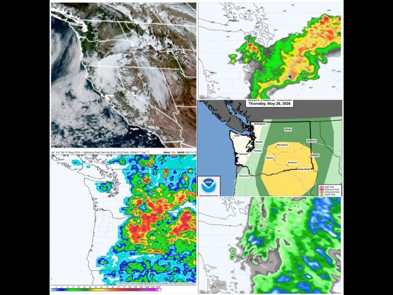
SPOKANE, WA — A significant severe weather threat is set to impact Eastern Washington and portions of Eastern Oregon on Thursday as a low pressure system parked over Lake Tahoe spins unstable air and moisture northward, prompting NOAA’s Storm Prediction Center to issue a Level 2 out of 5 severe weather risk for a broad corridor spanning from Wenatchee south through the Columbia Basin, Columbia Gorge, and down toward John Day, Oregon.
Eastern Washington Bears the Brunt
The primary severe weather threat on Thursday is firmly concentrated east of the Cascades, where the combination of moisture, instability, and wind shear will support the development of strong to severe thunderstorms capable of producing damaging wind gusts exceeding 60 miles per hour and large hail stones of one inch diameter or greater.
The Level 2 severe risk designation from the Storm Prediction Center is a relatively rare occurrence for the Inland Northwest, typically materializing only a handful of times annually, underscoring the significance of the atmospheric setup developing across the region for Thursday’s storm activity.
Lightning and Fire Weather Concern
Beyond the immediate threats of damaging winds and large hail, widespread and frequent lightning is expected across Central and Eastern Washington and extending into the Cascade foothills throughout Thursday’s active period.
Lightning ignitions represent a serious concern in this region during late spring, particularly across forested and grass covered terrain that can carry fire readily under gusty wind conditions associated with severe thunderstorm outflow, making Thursday’s event one that land management and fire weather agencies will be monitoring with considerable attention throughout the day.
Western Washington Escapes the Severe Threat
While Eastern Washington contends with severe thunderstorm potential, Western Washington including Seattle faces an entirely different and far more benign forecast on Thursday, with temperatures warming to near or slightly above 80 degrees under mostly sunny skies representing a classic false summer pattern west of the mountains.
Any thunderstorm activity that develops east of the Cascades may push westward into the foothills during Thursday evening and overnight, but models suggest storms will lose their electrical intensity after sunset, leaving Western Washington with primarily leftover rain rather than meaningful lightning by the time the line arrives.
Weekend Recovery and Warming Ahead
Following Friday’s cooler and cloudier conditions with highs only reaching the 60s due to a marine push, temperatures will begin a gradual recovery through the weekend with low to mid 60s giving way to 70s by Monday and potentially mid 80s during the middle of next week before another cooling trend develops toward the following weekend. For continuing coverage of severe weather threats and Pacific Northwest storm analysis, visit SaludaStandard-Sentinel.com.