Rotating Supercell Strikes Bedford Texas With Extreme Radar Cores and Confirmed Midlevel Rotation Tracked Across the DFW Metroplex
BEDFORD, TX — A fully rotating supercell thunderstorm swept through the northern Dallas-Fort Worth Metroplex Sunday morning, generating intense radar returns and confirmed midlevel rotation as it tracked northeast across Bedford, Colleyville, Grapevine, and Southlake around 11 a.m. local time.
What the Radar Showed
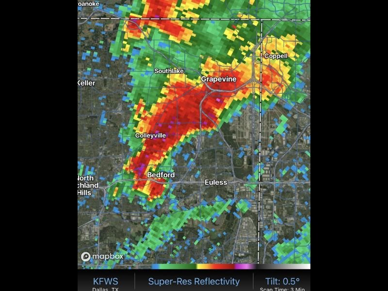
KFWS Super-Resolution Reflectivity data at the 0.5° base tilt revealed a tightly organized, northeast-tracking storm core with deep red and magenta pixels centered over Bedford and Colleyville — values consistent with 60 to 65+ dBZ reflectivity. Signatures of that magnitude are associated with very heavy rainfall, significant hail potential, and structurally organized convection.
Isolated pink pixels embedded within the core are consistent with large hail markers on dual-polarimetric radar, suggesting hailstones of notable size were possible within the most intense portion of the storm.
Rotation Confirmed But Elevated
The supercell’s rotation was well-confirmed at the time of the scan, though the rotation was occurring well above the ground rather than at the surface. That vertical positioning significantly reduces the immediate tornado threat, as low-level wind shear — the primary driver of surface tornado development — was not sufficient to bring rotation down to ground level.
Despite the reduced tornado risk, the storm still met the criteria of a fully organized supercell, which by definition carries the potential for rapidly evolving conditions.
Communities in the Storm’s Path
The storm’s northeast track brought it directly over some of the most densely populated communities in Tarrant County. Bedford, Colleyville, Grapevine, and Southlake all fell within or immediately adjacent to the storm’s primary core, with Euless and Coppell positioned along the projected forward path.
Residents in these areas faced threats including damaging winds, heavy rainfall, dangerous lightning, and the possibility of large hail during the storm’s passage.
What Residents Should Know
Even when tornado risk is low, a rotating supercell demands serious attention. These storms can produce wind gusts exceeding 60 mph, quarter-sized or larger hail, and flash flooding in low-lying areas — all within minutes of rapid intensification.
Anyone in the DFW Metroplex is urged to monitor NOAA Weather Radio and local National Weather Service alerts during any active supercell situation in the region. For continuing coverage of severe weather events and critical storm analysis across the United States, visit SaludaStandard-Sentinel.com.