Severe Thunderstorms Return to Colorado Monday With Damaging Winds Large Hail and Tornadoes Targeting Areas Along I-70 North Platte and the Palmer Divide
DENVER, CO — Severe thunderstorm risk returns to Colorado and the surrounding High Plains region Monday, June 8, with storms expected to fire initially along the foothills and Interstate 25 corridor before tracking northeast and intensifying into dangerous clusters capable of producing damaging winds, large hail, and tornadoes.
Where Storms Will Develop First
Initial storm development is expected to bubble up across the foothills and along the I-25 corridor, including the Palmer Divide — a terrain feature northeast of Colorado Springs known for triggering convective initiation. Early storms in this zone will be worth watching closely as they organize before moving into a more favorable environment to the northeast.
Fort Collins, Denver, and Colorado Springs all sit near the early development zone, placing the Front Range corridor under scrutiny during the afternoon hours before storms accelerate away to the northeast.
How the Threat Grows
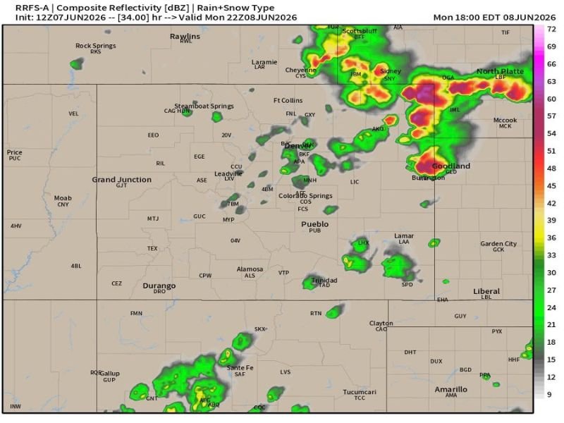
As storms track northeast away from the foothills, they will encounter increasing instability and wind shear, causing them to grow upscale into clusters and strengthen significantly. RRFS-A composite reflectivity data valid Monday at 18:00 EDT shows intense cores — with values reaching 63 to 69+ dBZ — concentrated across northeastern Colorado and into the Nebraska Panhandle near Sidney, Scottsbluff, and North Platte.
The magenta and deep red pixels on the radar forecast model indicate the potential for extremely heavy precipitation cores and large hail within the strongest cells as they mature.
Areas Facing the Greatest Risk
The highest threat corridor runs along and north of Interstate 70 and east of Interstate 25, favoring northeastern Colorado communities including Goodland, Burlington, and Lamar, as well as the Nebraska Panhandle. This zone sits squarely in the path of strengthening storm clusters as they push into the Plains through Monday evening.
Isolated activity is also depicted across southeastern Colorado near Pueblo and Trinidad, as well as portions of New Mexico near Santa Fe and Tucumcari.
What Residents Should Do
Anyone along the I-70 corridor in northeastern Colorado and the Nebraska Panhandle should monitor conditions closely throughout Monday afternoon and evening. Damaging winds, large hail, and the possibility of tornadoes demand that residents have a shelter plan ready before storms arrive.
For continuing coverage of severe weather across Colorado and the United States, visit SaludaStandard-Sentinel.com.