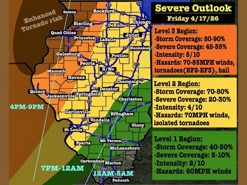
Illinois Severe Weather Outbreak Friday With EF3 Tornadoes, 85 MPH Winds, and Golf Ball Hail Threatening Chicago, Peoria, and St. Louis Areas
ILLINOIS — Friday, April 17, 2026, is shaping up to be an extremely dangerous severe weather day across Illinois, with a three-tiered threat level system placing millions of residents at risk from EF2 to EF3 tornadoes, winds gusting up to 85 mph, golf ball sized hail, and widespread severe thunderstorm coverage from the Chicago metro southward through St. Louis and beyond. Storm coverage across the highest risk zone is expected to reach 80 to 90 percent, meaning the vast majority of residents in the Level 3 region will see severe weather Friday.
The threat is forecast to unfold in two distinct phases — isolated supercells between 1 PM and 6 PM followed by a dangerous squall line pushing through between 5 PM and 8 PM across the northern and central portions of the state.
Level 3 Region Faces Greatest Danger
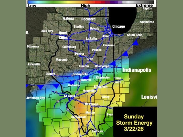
The Level 3 region covering the Rockford, Chicago, Quad Cities, Peoria, Bloomington, and Champaign corridor faces the most extreme threat Friday. Severe coverage sits at 45 to 55 percent, meaning roughly 1 in 2 people in this zone will experience severe weather. Hazards include winds of 70 to 85 mph, numerous tornadoes potentially reaching EF3 strength, and golf ball sized hail.
Supercells are expected between 1 PM and 6 PM carrying all hazards before a squall line arrives between 5 PM and 8 PM bringing the most widespread damaging winds and embedded tornadoes across the region.
Level 2 Region Covers Springfield to St. Louis Corridor
The Level 2 region stretching through Springfield, Jacksonville, Decatur, Effingham, Carlinville, and St. Louis carries a 20 to 30 percent severe coverage chance with 70 mph damaging winds and isolated tornadoes as the primary threats. The squall line arrives in this zone between 4 PM and 9 PM, with quick and brief but potentially strong tornado touchdowns possible as the line moves through.
Tornado risk in this zone sits at 5 to 9 percent — while the odds of a tornado near any single location remain below 10 percent, forecasters noted that numerous brief tornado touchdowns are commonly observed in setups with these probability levels.
Level 1 Region and Overnight Threat
Southern Illinois communities including Carbondale, Marion, and Paducah fall into the Level 1 region, where severe coverage drops to 5 to 10 percent with 60 mph wind gusts as the main hazard. Timing for this southernmost zone runs from 7 PM through 12 AM and into the early morning hours of 12 AM to 5 AM.
All residents across Illinois should have emergency alerts active and shelter plans finalized well before noon Friday. Are you preparing for Friday’s severe weather outbreak across Illinois? Stay safe and follow our continuing coverage at SaludaStandard-Sentinel.com.