Heavy Rain and Mountain Snow Begin Across Colorado Front Range as Boulder, Denver, and Castle Rock Corridor See Active Precipitation With Longer Event Extending Through Wednesday
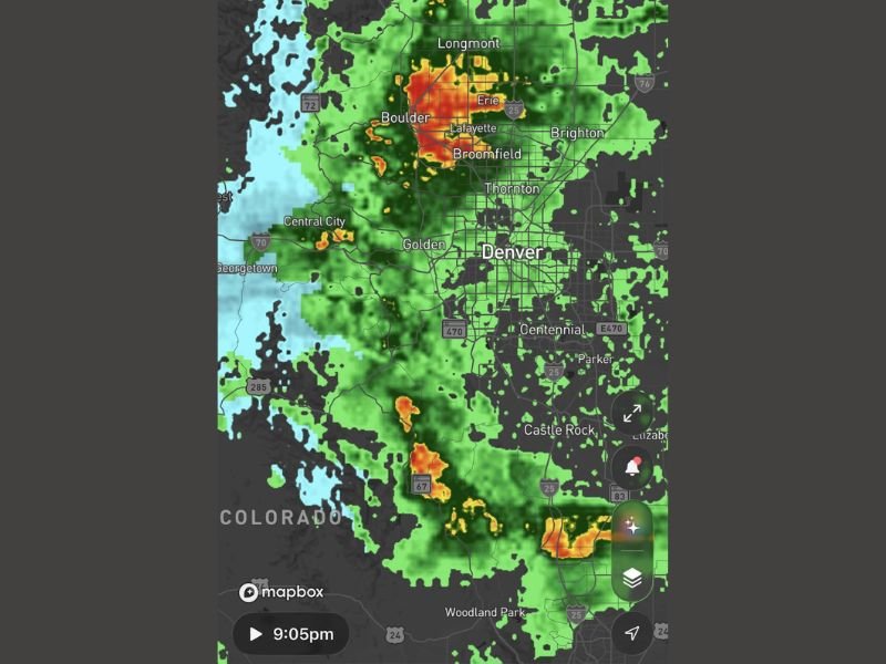
DENVER, CO — Good rain was already falling across portions of the Colorado Front Range on Monday evening as an appetizer to a significantly more impactful weather system expected to develop through Tuesday and extend into Wednesday, with radar captured at 9:05 PM showing active and heavy precipitation cores concentrated across the Boulder, Lafayette, Erie, Broomfield, and Golden corridor north and west of Denver.
The most intense rainfall returns were centered over Boulder and Lafayette, with deep red and orange reflectivity cores indicating heavy precipitation rates across the northern Denver metro area while lighter green returns spread across the broader Front Range from Longmont southward through Denver, Centennial, Parker, and Castle Rock.
Front Range Rain and Mountain Snow Already Underway
The Monday evening precipitation represented the leading edge of the multi-day weather system pushing into Colorado, with rain falling across the Front Range urban corridor while snow was simultaneously developing across the higher mountain terrain to the west. The light blue returns visible on radar across the mountain zones west of Golden, Georgetown, and Central City confirmed the snow component of the system was already active across the elevated terrain well before the main event arrived Tuesday.
The early Monday evening precipitation served as confirmation that the anticipated weather system was on track and developing as forecast ahead of the more significant Tuesday through Wednesday impact period.
Long Day Ahead Tuesday Into Wednesday
The Monday evening rain and mountain snow were only the beginning of an extended weather period across Colorado, with a long and active Tuesday forecast to push into Wednesday across the Front Range and mountain communities. The full scope of the Tuesday through Wednesday system carried the potential for significant mountain snow accumulations and continued Front Range precipitation across Denver, Boulder, Fort Collins, Castle Rock, and surrounding communities.
Residents across the Colorado Front Range and mountain corridor were advised to prepare for a lengthy and impactful weather period beginning Tuesday morning and continuing through Wednesday as the full system moved through the state. For continuing coverage of weather events and critical storm analysis across the United States, visit SaludaStandard-Sentinel.com.