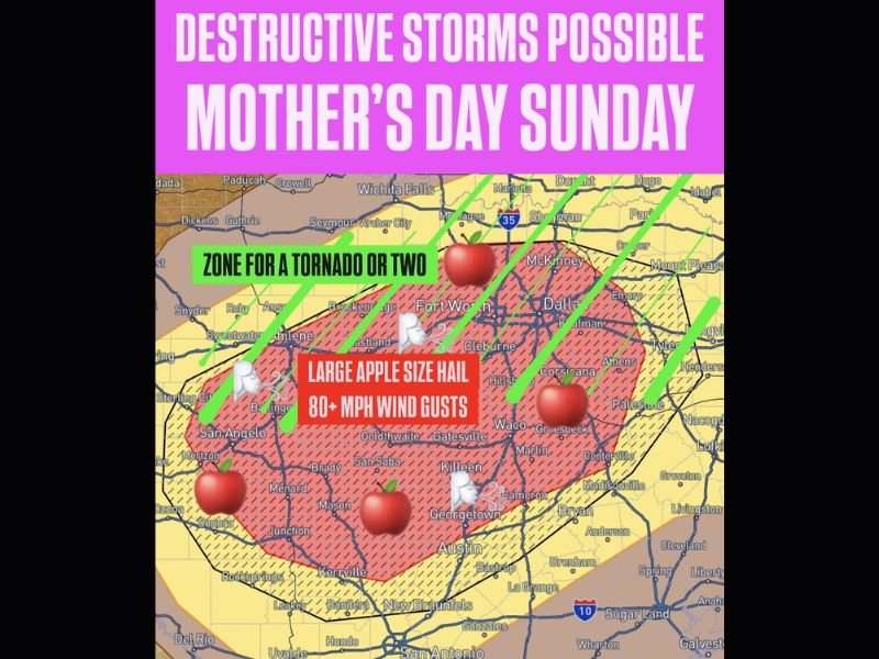
Apple Size Hail and 80 MPH Winds With Tornado Risk to Strike Texas From DFW Metro to Big Country on Mothers Day Sunday as Destructive Storms Build Through the Afternoon and Evening
FORT WORTH, TX — Destructive severe storms are expected to impact a large swath of Texas on Mother’s Day Sunday, with the core threat zone encompassing the Dallas-Fort Worth Metroplex westward through the Big Country and southward through Waco, Killeen, and into the San Angelo area, where apple size hail, wind gusts exceeding 80 miles per hour, and a low-end tornado risk combine to create one of the more significant severe weather setups of the spring season across central Texas.
Apple Size Hail and 80 MPH Winds in Core Threat Zone
The most extreme hazards are concentrated within the primary red-shaded threat zone stretching from the Texas Big Country through Fort Worth, Dallas, Cleburne, Waco, and Killeen, where apple size hail and wind gusts surpassing 80 miles per hour are explicitly highlighted as the dominant destructive threats. Apple size hail, measuring approximately 3 inches in diameter, is capable of causing catastrophic damage to vehicles, destroying roofing materials, shattering windows, and posing a direct life-threatening risk to anyone caught outdoors during the storm’s passage.
Wind gusts exceeding 80 miles per hour represent hurricane-force equivalent wind speeds capable of leveling trees, destroying outbuildings, and causing significant structural damage across the entire core threat corridor simultaneously.
Tornado Risk Across DFW Metro Into ArkLaTex
Beyond the hail and wind threats, forecasters identify a zone for a tornado or two stretching across the broader DFW Metroplex area, extending from the Texas Big Country through McKinney, Sherman, and into the ArkLaTex region. While the tornado risk is characterized as low-end rather than a primary outbreak threat, even isolated tornado development within such a heavily populated metropolitan corridor carries serious public safety implications for millions of residents across the warned zone.
Communities including Wichita Falls, Fort Worth, Dallas, McKinney, and Tyler all fall within the broader tornado risk area identified for Sunday afternoon and evening.
Higher Risk Develops Sunday Afternoon Into Evening
While a few morning severe storms are possible across Oklahoma, north Texas, and Arkansas carrying gusty winds and hail, the higher-end severe weather risk develops during Sunday afternoon and continues into the evening hours as daytime heating and increasing instability fuel more organized and destructive storm development across the central Texas threat zone.
Residents across the entire affected corridor are urged to complete any outdoor Mother’s Day plans before midday and have shelter plans firmly in place well ahead of the Sunday afternoon severe weather window.
Multiple Warning Methods Essential for Sunday
Given the scope and intensity of Sunday’s severe weather potential across Texas, forecasters strongly urge all residents within the threat zone to have multiple methods of receiving warnings active throughout the day, including wireless emergency alerts, weather radios, and local broadcast monitoring, ensuring no warning goes unnoticed during what could be a rapidly evolving and dangerous afternoon severe weather event.
For continuing coverage of severe weather events and critical storm analysis across the United States, visit SaludaStandard-Sentinel.com.