Flash Flood Warning Canceled for Atlanta Metro as Heavy Rain and Storms Continue Overnight Across North and Central Georgia Through Friday Night
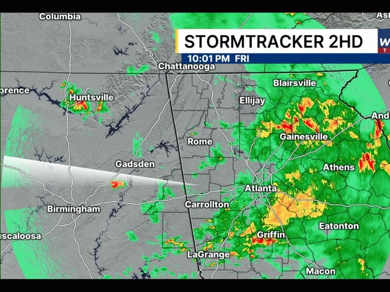
ATLANTA, GA — The flash flood warning previously in effect for the Atlanta metropolitan area has been officially canceled Friday night as the immediate flash flood threat diminishes across the metro region, though heavy rain and thunderstorms continue pushing through north and central Georgia with radar showing active and intense precipitation cores across a broad swath of the state as of 10:01 PM Friday.
Flash Flood Threat Ends for Metro Atlanta
The cancellation of the flash flood warning for the Atlanta metro area marks a significant improvement in the immediate danger level for one of the most densely populated regions in the southeastern United States, offering relief to residents who had been under elevated flood threat during the earlier portion of Friday evening’s storm event.
While the warning has been lifted, forecasters caution that heavy rain continues falling across the metro area and surrounding communities, meaning localized ponding on roadways and in low lying areas remains possible through the overnight hours even without an active flash flood warning in place.
Heavy Rainfall Continues Across North Georgia
Radar imagery captured at 10:01 PM Friday shows the most intense storm activity concentrated across the north Georgia corridor, with deep red and yellow reflectivity values indicating heavy to extreme rainfall rates across communities including Gainesville, Athens, Blairsville, Ellijay, and the Anderson area near the South Carolina border.
The northeastern Georgia mountain and foothill communities face continued elevated rainfall through the overnight period as the storm system slowly progresses across the region, with terrain-driven rainfall enhancement potentially producing locally higher accumulations across the more elevated portions of the north Georgia landscape.
Central Georgia Still in the Rain Shield
South and southeast of Atlanta, radar shows continued heavy precipitation across the Griffin, Eatonton, and LaGrange corridor, with the broader green precipitation shield extending across central Georgia toward Macon and Augusta indicating that widespread rainfall will persist well into the overnight hours across a large portion of the state.
Motorists across central Georgia are reminded that even after flash flood warnings expire, flooded roadways can remain extremely dangerous and should never be crossed regardless of apparent water depth during or immediately following heavy rainfall events.
Overnight Improvement Expected
Conditions are expected to gradually improve across the region as the storm system continues its eastward progression through the overnight hours, with rainfall intensity expected to diminish across the western portions of the affected area before clearing develops more broadly heading into Saturday morning.
For continuing coverage of Georgia flood events and severe weather impacts across the United States, visit SaludaStandard-Sentinel.com.