Severe Thunderstorm Warning in Effect for Eastern Texas Panhandle Until 9:30 PM With Ping Pong Ball Hail and 60 MPH Gusts Targeting Memphis Lakeview and Plaska
MEMPHIS, TX — A Severe Thunderstorm Warning was issued for portions of the eastern Texas Panhandle Friday evening, with dangerous storms tracking eastward at 20 to 25 miles per hour through a corridor stretching from Clarendon and Lelia Lake through Hedley, Giles, Memphis, and Brice, bringing the threat of ping pong ball sized hail, 60 mile per hour wind gusts, heavy rain, and frequent lightning to communities in Hall and surrounding counties until 9:30 PM CDT.
Warning Details and Storm Motion
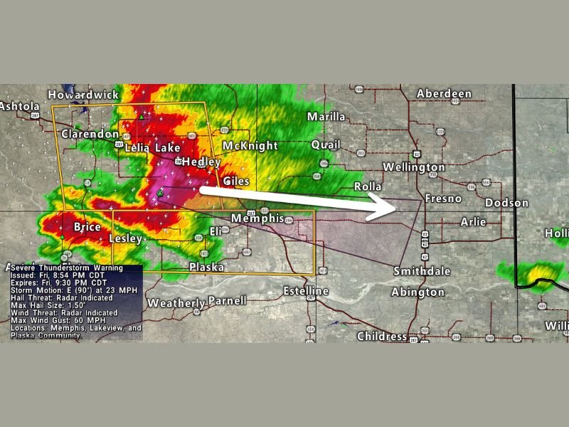
The Severe Thunderstorm Warning was issued at 8:54 PM CDT and carries a expiration of 9:30 PM CDT, with the warned storm moving due east at 23 miles per hour along a track that places Memphis, Lakeview, and Plaska communities directly in the path of the most intense storm activity during the valid warning timeframe.
Radar reflectivity imagery captured at 8:56 PM CDT by Texas Storm Chasers shows an extremely intense and well-organized storm core displaying deep red and magenta reflectivity values concentrated across the Clarendon to Lelia Lake corridor and tracking aggressively eastward toward the Memphis and Plaska areas with substantial lightning activity embedded throughout the warned cell.
Ping Pong Ball Hail Confirmed as Threat
The warning specifically identifies a maximum hail size threat of 1.5 inches in diameter, equivalent to the size of a ping pong ball, based on radar-indicated hail signatures within the storm core at the time of issuance.
Hail of this size falls with sufficient velocity and mass to cause meaningful damage to vehicle surfaces, strip foliage from trees, crack windows, and injure anyone caught outdoors without protection during the storm’s passage through the warned communities across the eastern Texas Panhandle landscape.
60 MPH Wind Gusts Add to the Danger
Alongside the significant hail threat, radar-indicated wind gusts up to 60 miles per hour represent a concurrent and equally serious hazard for residents across the warned area, a wind speed capable of downing trees and large branches, damaging roofing materials and siding, and producing scattered power outages across Hall County and adjacent communities in the storm’s eastward path.
The combination of large hail, damaging winds, heavy rainfall, and frequent lightning makes this a multi-hazard severe weather event requiring immediate protective action from all residents within the warned zone.
Immediate Shelter Directive
All residents across Memphis, Lakeview, Plaska, and surrounding eastern Texas Panhandle communities were directed to move indoors immediately, stay away from windows, and remain sheltered in an interior room on the lowest floor of a sturdy structure until the warning expires and radar confirms the storm has cleared the immediate area.
For continuing coverage of severe thunderstorm warnings and Texas storm events across the United States, visit SaludaStandard-Sentinel.com.