Large Hail Damaging Winds and Tornadoes Possible Across Colorado Kansas Nebraska and Wyoming as Active Severe Weather Pattern Builds Through Mid June 2026
DENVER, CO — Long range forecast guidance and accumulated Supercell Composite Parameter data are raising increasing signals that the Central Plains will experience a notably active and potentially dangerous severe weather pattern through the first half of June 2026, with Colorado, western Kansas, Nebraska, and Wyoming identified as the primary corridor where instability, moisture, wind shear, and lift are expected to overlap most consistently across multiple forecast periods.
What the Supercell Composite Parameter Is Showing
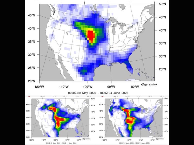
Accumulated Supercell Composite Parameter maps spanning three consecutive two-week windows from late May through June 18, 2026 depict a progressively intensifying and expanding severe weather environment across the central United States, with the deepest and most concentrated values shown in deep red and yellow shading centered across a corridor roughly spanning Nebraska, Kansas, and the surrounding plains states.
The first period from May 29 through June 4 shows a focused but significant composite parameter axis centered across the central plains. The June 5 through June 11 and June 12 through June 18 windows both show dramatically broader and more intense coverage expanding across a larger swath of the country, suggesting the severe weather environment becomes increasingly supportive as June progresses.
What This Means and Does Not Mean
The Supercell Composite Parameter is one ingredient meteorologists use to identify atmospheric environments favorable for strong to severe thunderstorm development, but it does not guarantee severe weather outbreaks on any specific day or at any specific location within the highlighted region.
When instability, moisture, wind shear, and atmospheric lift simultaneously overlap across a corridor, conditions become supportive for supercell thunderstorms capable of producing large hail, damaging winds, and tornadoes, but the precise timing, location, and intensity of individual events remains impossible to pinpoint at ranges of 10 to 20 days in advance.
Multiple Rounds of Storms Likely
The consistency with which long range guidance is depicting favorable severe weather ingredients across the Central Plains through the first half of June suggests the atmosphere will support multiple rounds of thunderstorm activity, with at least some events carrying potential for large hail, damaging wind gusts, and isolated tornado opportunities across portions of Colorado, Nebraska, Kansas, and Wyoming.
Residents across the central plains states are encouraged to remain engaged with updated forecasts as the June pattern develops and higher resolution model guidance begins capturing individual event details with greater confidence in the days ahead. For continuing coverage of severe weather pattern analysis and Central Plains storm threats across the United States, visit SaludaStandard-Sentinel.com.