Rapidly Increasing Severe Weather With Large Hail Strong Winds and Tornadoes Strikes Northern Arkansas as Supercells Move East Targeting Mountain Home Batesville and Pocahontas
NORTHERN ARKANSAS — A rapidly intensifying severe weather threat swept across northern Arkansas on Monday evening as supercell thunderstorms moved eastward as of 10 PM, bringing a dangerous combination of large hail, strong winds, and tornado potential across north central, eastern, and northeast Arkansas communities.
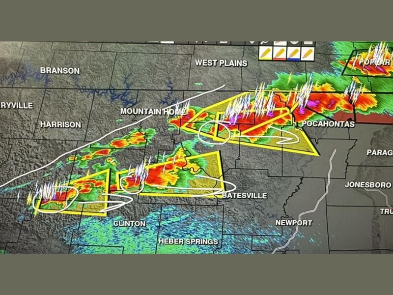
Arkansas Weather Network radar captured at 9:57 PM showed multiple intense storm cells tracking across a broad corridor stretching from the Harrison and Mountain Home area eastward through Batesville and toward Pocahontas, with the environment across the described region rated as very favorable for rotating storm development.
Supercells Create Highly Favorable Rotating Storm Environment
The atmospheric setup across northern Arkansas on Monday evening created conditions highly conducive to supercell thunderstorm organization and rotation. Multiple storm cells visible on radar displayed intense reflectivity cores with wind shear indicators confirming the rotating nature of the supercells pushing through the region.
The combination of large hail, strong winds, and tornado risk within an environment this favorable for rotation elevated the threat level significantly for communities positioned along the eastward storm track across north central and northeast Arkansas.
Communities Along the Storm Track at Immediate Risk
Radar imagery showed active and intense storm cells tracking across a wide corridor impacting Mountain Home, Batesville, Pocahontas, West Plains, and Poplar Bluff along the northern track. Harrison and Berryville were positioned within the western edge of the developing severe weather corridor as storms organized and pushed east.
Further along the track, Paragould, Jonesboro, Newport, and Trumann fell within the broader area of concern as the supercells continued their eastward progression through the late evening hours across northeastern Arkansas.
Large Hail and Tornado Threat Demands Immediate Awareness
Large hail accompanying the supercell complex posed an immediate threat to property, vehicles, and anyone caught outdoors across the warned corridor. Alongside the hail risk, the tornado threat remained an active concern given the highly favorable rotating storm environment confirmed across north central and northeast Arkansas.
Strong wind gusts within and around the storm cells added a third hazard layer, making the overall severe weather package significant for communities directly in the path of the eastward-moving supercells through the Monday night timeframe.
Southern Arkansas Remains Clear for Now
Communities south of the north central and northeast Arkansas corridor were not included in the immediate severe weather concern as of Monday evening. Residents in central and southern portions of the state were advised that conditions remained manageable, with the active severe threat confined to the northern tier of Arkansas as storms tracked eastward through the overnight hours.
For continuing coverage of severe weather events and critical storm analysis across the United States, visit SaludaStandard-Sentinel.com.