Severe Thunderstorm Watch With Damaging Winds Tornado Potential and Flooding Rain Moves Into Western Ohio Along and West of I-75 Until 4 AM Tuesday April 27
WESTERN OHIO — A Severe Thunderstorm Watch was issued for areas along and west of Interstate 75 in western Ohio until 4:00 AM as a line of severe storms moved into the region at 11:40 PM Monday, April 27, bringing damaging winds, tornado potential, heavy rainfall, and flooding concerns across a broad corridor stretching from Fort Wayne and Lima southward through Indianapolis, Dayton, and Cincinnati.
While storms were forecast to weaken as they crossed into western Ohio, the system retained the potential to remain briefly severe during the crossing, keeping residents along and near the I-75 corridor on high alert through the overnight hours.
Damaging Winds and Tornado Potential Accompany the Line
The incoming line of severe storms was producing damaging winds across multiple cells, with a few storms within the line carrying the potential for tornado development as they pushed eastward into Ohio. The combination of an organized squall line structure and embedded rotation within individual cells created a layered hazard environment for communities positioned along and west of the I-75 corridor.
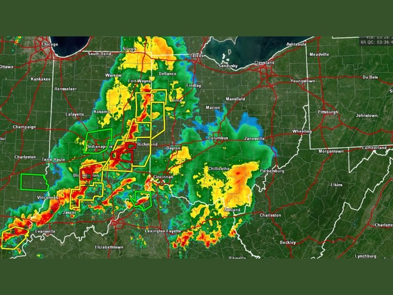
Radar imagery showed intense storm activity pushing through the Indianapolis and Bloomington area with warning polygons outlined across multiple counties in yellow and red, reflecting the active severe thunderstorm and tornado warned cells tracking toward western Ohio communities including Richmond, Dayton, and the greater Cincinnati region.
Flooding Rain Adds Third Hazard Layer
Beyond the wind and tornado threat, heavy rainfall accompanying the storm system raised the possibility of flooding across portions of western Ohio through the overnight hours. Flooding from heavy rainfall events can develop rapidly during overnight hours when visibility is limited and drainage systems become overwhelmed, adding a significant and potentially life-threatening hazard beyond the immediate wind and tornado concerns associated with the squall line.
Residents in low-lying areas and near waterways across the warned corridor were advised to monitor conditions closely and avoid any flood-prone roadways through the early morning hours.
I-75 Corridor Residents Urged to Stay Weather Alert
With the storm system actively crossing into western Ohio and the severe thunderstorm watch valid until 4:00 AM, residents particularly near the I-75 corridor were strongly urged to stay weather alert through the overnight hours. The brief but potentially severe nature of storms as they crossed into Ohio meant that warning times could be short and immediate shelter response was essential for anyone in the direct path of the advancing line.
Active weather alert notifications, charged devices, and a ready shelter plan represented the minimum preparation required for all residents across the warned area west of I-75 through the 4:00 AM watch expiration.
For continuing coverage of severe weather events and critical storm analysis across the United States, visit SaludaStandard-Sentinel.com.