Eight States With Intense Tornadoes Likely Golf Ball Sized Hail and 70 MPH Winds Threatening Alabama Arkansas Illinois Indiana Kentucky Missouri Mississippi and Tennessee
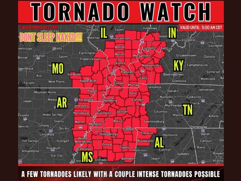
LOWER OHIO VALLEY — A Tornado Watch was issued across eight states covering Alabama, Arkansas, Illinois, Indiana, Kentucky, Missouri, Mississippi, and Tennessee until 5:00 AM CDT, as a dangerous overnight severe weather outbreak brought likely tornado development, a few intense tornadoes possible, large hail up to 1.5 inches in diameter, and damaging winds reaching 70 miles per hour across a massive multi-state corridor.
Storms were expected to continue pushing east-southeast overnight, organizing into a line across the Lower Ohio Valley, Mid-Mississippi Valley, and Mid-South, with the line carrying the capacity for widespread damaging winds and quick spin-up tornadoes embedded within the squall structure.
Intense Tornadoes Possible as Watch Covers Massive Area
The tornado watch carried a significant and explicit threat level, with a few tornadoes rated as likely and the possibility of a couple of intense tornadoes developing across the eight-state watch area through the overnight hours. The watch zone encompassed a vast geographic stretch running from southern Illinois and Indiana through western Kentucky, Tennessee, Arkansas, Mississippi, and into northern Alabama.
Communities across Paducah, Evansville, Marion, Mt. Vernon, Madisonville, Bowling Green, Memphis, Jonesboro, Paragould, Dyersburg, Corinth, Florence, Russellville, Tupelo, and surrounding areas all fell within the active tornado watch boundary through the 5:00 AM CDT expiration.
Storm Line Threatens Lower Ohio and Mid-Mississippi Valley
The primary storm mode for the overnight event was a consolidating line of severe thunderstorms pushing east-southeast through the Lower Ohio Valley, Mid-Mississippi Valley, and Mid-South region. Lines of this nature are particularly capable of producing widespread damaging winds and quick spin-up embedded tornadoes that develop with very little warning time, making continuous weather awareness essential for all residents within the watch zone.
The speed and organization of the approaching line elevated the overnight danger level significantly, particularly for residents in areas where warning lead times for embedded tornadoes within squall lines can be considerably shorter than for discrete supercell events.
Discrete Storms Ahead of the Line Add Additional Threat
Ahead of the main storm line, additional discrete storm development was possible across northern Mississippi and far northwest Alabama. These discrete storms carried the potential to intensify rapidly and produce the full hazard suite including tornadoes and large hail, making them a particularly dangerous element of the overnight severe weather setup for those specific communities.
Large hail ranging from ping pong to golf ball size, measuring up to 1.5 inches in diameter, represented a significant property and personal safety hazard accompanying the storm system through the overnight watch period.
Eight States Must Stay Alert Through Overnight Hours
With the tornado watch valid until 5:00 AM CDT, residents across all eight states were urged to remain alert through the overnight hours, keep weather alert devices active and fully charged, and have an established shelter plan ready for immediate execution if a tornado warning was issued for their specific county or community.
For continuing coverage of severe weather events and critical storm analysis across the United States, visit SaludaStandard-Sentinel.com.