South Dakota and Nebraska Face Early April Storm System With Snow Expected Near Rapid City and Rain Spreading Across Plains
SOUTH DAKOTA, NEBRASKA — A developing upper-level storm system is expected to bring a mix of snow and rain to parts of the northern Plains by early April, with South Dakota and Nebraska positioned directly in its path.
Forecast models indicate the system will strengthen as it moves toward the region, with snow likely across western South Dakota, including areas near Rapid City, while rain spreads across much of Nebraska.
Upper-Level Storm System Takes Shape Over the Plains
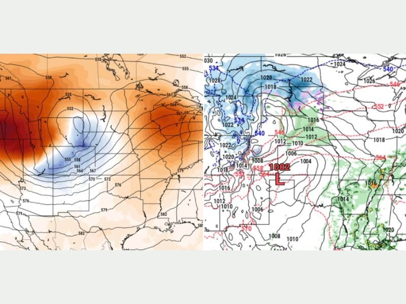
Meteorologists are tracking a well-defined upper-level low that is expected to move into the central United States by April 3. This type of system is known for producing widespread precipitation and dynamic weather conditions.
The storm’s structure suggests a strong circulation pattern, with colder air wrapping into the northern side of the system while warmer, moisture-rich air feeds into the southern and eastern portions. This setup creates the potential for multiple types of precipitation across relatively short distances.
Snow Likely Across Western South Dakota
As the system approaches, colder air will dominate across South Dakota, particularly in western areas near Rapid City. This will allow precipitation to fall as snow instead of rain.
While exact snowfall totals remain uncertain, the setup indicates a meaningful chance for accumulating snow, especially in higher elevations and areas closer to the core of the storm. This late-season snowfall could create travel concerns depending on timing and intensity.
Rain Expected Across Nebraska
Further south, Nebraska is expected to remain on the warmer side of the system, leading to rain instead of snow. Moisture drawn into the storm will support widespread rainfall across much of the state.
Rainfall could be steady at times, contributing to wet conditions across roads and fields. The system’s strength may also bring periods of gusty winds, adding to the overall impact. This rain will be beneficial in some areas but could also lead to localized issues if heavier bands develop.
Sharp Weather Gradient Between Snow and Rain Zones
One of the key features of this system will be the sharp transition zone between snow and rain. Areas near the South Dakota–Nebraska border may see a mix of precipitation depending on slight temperature changes.
This boundary could shift as the storm evolves, making precise forecasting more challenging. Small changes in temperature could determine whether precipitation falls as rain, snow, or a combination of both. Residents near this transition zone should monitor updates closely as conditions develop.
Early April Pattern Signals Active Spring Weather
This storm system highlights the active and often unpredictable nature of early spring weather across the Plains. It is common for strong systems during this time of year to produce both winter and spring conditions simultaneously.
As the pattern remains active, additional systems may follow, continuing the trend of fluctuating temperatures and varied precipitation types. The evolving setup underscores the importance of staying informed as forecasts are refined in the coming days.
Have you experienced late-season snow or shifting weather patterns in your area recently? Share your experience and stay updated with the latest forecasts at SaludaStandard-Sentinel.com.