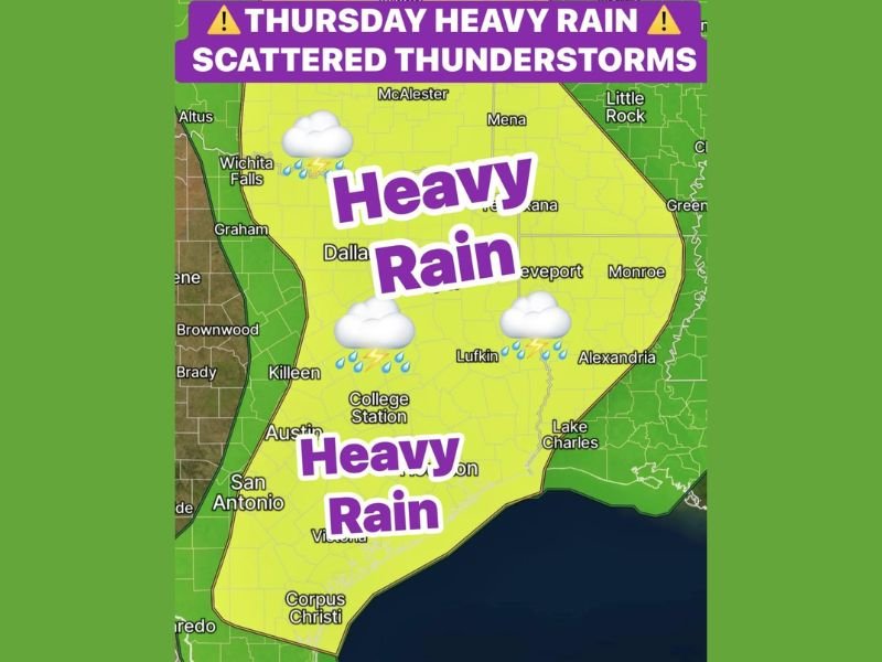
Heavy Rain and Scattered Thunderstorms Target North and Central Texas Thursday With Flash Flooding Concerns Frequent Lightning and Small Hail Possible Through the Afternoon
DALLAS, TX — A new disturbance arriving Thursday morning will bring heavy rain and scattered thunderstorms across a broad swath of North and Central Texas, with storm coverage increasing through the afternoon as daytime heating intensifies convective development across the region. The heavy rain threat zone covers a large yellow shaded corridor stretching from Wichita Falls and Dallas southward through Austin, San Antonio, and Corpus Christi, with isolated flash flooding concerns developing where storms train repeatedly over the same areas from southwest to northeast.
Scattered Showers Develop Thursday Morning Before Storms Intensify Through the Afternoon
The incoming disturbance will trigger scattered shower development across North Texas during the morning hours, with storm coverage and intensity increasing significantly through the midday and afternoon period as surface heating adds instability to the already moisture rich airmass across the region. The heaviest rainfall is expected to occur around midday into the afternoon hours, coinciding with the period of maximum daytime heating and peak storm development across the Dallas, Killeen, College Station, and surrounding corridors.
Storms are expected to gradually dissipate after 6:00 PM as daytime heating diminishes heading into the evening, with rain chances calming down around sunset across most of the affected region.
Flash Flooding Concerns Arise Where Storms Train Over the Same Areas
A key concern with Thursday’s storm setup is the potential for training thunderstorms, where multiple storm cells move repeatedly over the same geographic areas from southwest to northeast along a common storm motion pathway. When storms train over a location, rainfall accumulations can escalate rapidly beyond what any single storm cell would produce, creating localized flash flooding conditions even in areas that would not otherwise be at elevated flood risk during a typical scattered storm event.
Communities across the Dallas metroplex, Texarkana, Lufkin, and the broader heavy rain zone are at the greatest risk for localized flash flooding should training storm activity develop and persist over specific areas during the peak afternoon storm window.
Frequent Lightning Gusty Winds and Small Hail Possible in Stronger Storms
Beyond the heavy rainfall and flash flooding threat, stronger individual thunderstorm cells developing Thursday afternoon carry the potential for frequent lightning, gusty winds, and small hail across the affected North and Central Texas corridor. Residents across Dallas, Wichita Falls, Austin, San Antonio, Corpus Christi, and all communities within the outlined heavy rain zone should remain weather aware through the afternoon hours and avoid outdoor activities during the most active storm period.
All residents across the Thursday heavy rain zone are encouraged to monitor updated flash flood watches and warnings and to never attempt driving through flooded roadways as storm activity peaks across the region.
For continuing coverage of heavy rainfall and storm forecasts across the United States, visit SaludaStandard-Sentinel.com.