Rare Cold-Weather Storm in Nebraska Produces 2-Inch Hail Near Friend and Daykin as Temperatures Sit in the 30s
NEBRASKA — A powerful thunderstorm moved across parts of southeastern Nebraska Friday evening, producing large hail up to 2 inches in diameter even as surface temperatures remained in the low to mid-30s across much of the region.
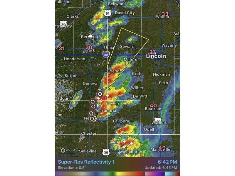
Radar imagery from the KUEX Hastings weather radar around 6:45 PM showed a strong storm cell tracking across areas south and west of Lincoln, including communities such as Friend, Daykin, Alexandria, and Geneva. Despite the unusually cold air at the surface, the storm intensified enough to generate damaging hail and intense lightning.
Meteorologists say events like this are uncommon but possible when strong thunderstorms develop in a cold environment where temperatures near the ground remain close to freezing.
Severe Storm Cell Develops South of Lincoln
Weather radar indicated a concentrated thunderstorm core forming across Saline, Jefferson, and surrounding counties in southeastern Nebraska.
The strongest portion of the storm was located near Friend and Daykin, where radar signatures suggested extremely strong updrafts capable of producing large hail.
A severe thunderstorm warning polygon highlighted the region stretching from Friend northeast toward Seward, indicating the storm’s projected movement toward areas west of Lincoln. Lightning activity within the storm was intense, with numerous lightning strikes detected as the storm strengthened.
Large Hail Reported Even With Freezing Temperatures
One of the most unusual aspects of the storm was the temperature contrast. Surface readings across parts of southeastern Nebraska were hovering between 30°F and 37°F, yet the storm still produced hail measuring up to 2 inches in diameter.
Large hail typically forms inside powerful thunderstorm updrafts where strong rising air repeatedly lifts hailstones into colder parts of the storm cloud, allowing them to grow larger before falling to the ground. In this case, meteorologists believe strong atmospheric instability above the cold surface layer helped the storm produce severe hail despite the chilly temperatures.
Storms Continue Tracking Northeast Across the Region
Radar data suggested the storm cluster would continue moving northeast toward Seward and areas west of Lincoln, while additional storm cells developed farther south near the Kansas–Nebraska border.
Communities across southeastern Nebraska were advised to remain alert as storms continued to develop and track through the region during the evening hours. Even though temperatures were near freezing, storms remained capable of producing large hail, lightning, and brief heavy precipitation.
Residents Urged to Stay Weather Aware
Weather officials urged residents across southeastern Nebraska to monitor alerts and remain cautious as severe storms move through the area. Large hail can cause significant damage to vehicles, roofs, and crops, while lightning and strong wind gusts can create additional hazards.
Meteorologists say storms developing in colder environments can still produce severe weather, making it important for residents to pay attention to radar and warning updates. Stay with Saluda Standard-Sentinel for continuing coverage as severe weather develops across Nebraska and the central United States.