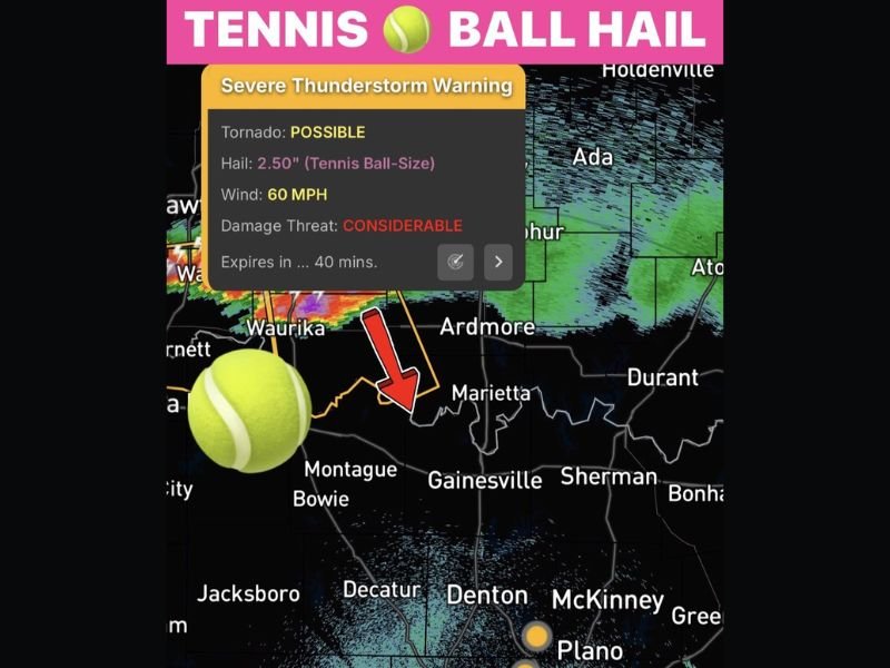
Tennis Ball Size Hail and 60 MPH Winds Crossing Red River Into North Texas as Severe Thunderstorm Warning Flags Considerable Damage Threat With Tornado Possible Until 2 AM
GAINESVILLE, TX — A Severe Thunderstorm Warning carrying a Considerable damage threat is active as dangerous storms producing tennis ball size hail measuring 2.50 inches cross the Red River from Oklahoma southward into North Texas tonight, with 60 mile per hour winds, a possible tornado, and a Severe Watch remaining in effect for parts of North Texas until 2 AM as the storm system continues dropping south through the region.
Tennis Ball Size Hail the Headline Threat
The most destructive element of this storm system is confirmed tennis ball size hail measuring 2.50 inches in diameter, a size capable of causing catastrophic damage to vehicles, shattering windows, destroying roofing materials, and causing serious injury to anyone caught outdoors during the storm’s passage.
Hail of this magnitude falls with enough force and velocity to cause immediate and severe damage across any community it passes through, and represents one of the most destructive hail size categories that can be associated with a severe thunderstorm event across the southern plains.
The storm system was confirmed producing this size hail across southern Oklahoma near Waurika before tracking southeast and crossing the Red River boundary into North Texas.
Considerable Damage Threat With Tornado Possible
The active Severe Thunderstorm Warning explicitly carries a Considerable damage threat designation, reflecting the high confidence that significant and widespread damage will occur across communities in the direct path of the warned storm. Beyond the hail and wind threats, the warning also flags a tornado as possible with this system, elevating the danger level further for residents across the Marietta, Gainesville, Sherman, and surrounding North Texas communities currently in the storm’s projected path.
Wind gusts of 60 miles per hour accompanying the storm are capable of downing trees, snapping utility lines, and causing structural damage across the affected corridor simultaneously with the hail threat.
Severe Watch Active for North Texas Until 2 AM
A Severe Thunderstorm Watch remains in effect for parts of North Texas until 2 AM as the parent storm system continues its southward progression across the Red River and into the state. Communities including Montague, Bowie, Decatur, Gainesville, Sherman, and surrounding areas all fall within the active threat zone as the storms drop south through the overnight hours.
Residents across all North Texas communities in the path of this system are urged to move vehicles into covered shelter immediately, stay indoors away from windows, and keep emergency alert systems active until the watch expires at 2 AM.
For continuing coverage of severe weather events and critical storm analysis across the United States, visit SaludaStandard-Sentinel.com.