Wet Wednesday Morning Rain Event Targets Columbia, Lexington, Saluda, Aiken and Augusta With Strong to Severe Weather Possible by Saturday Across South Carolina and Surrounding Region
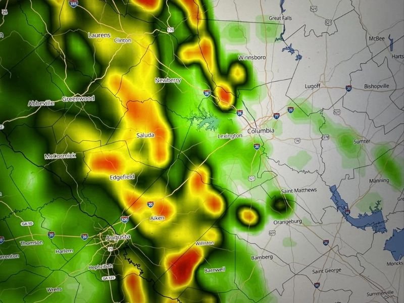
COLUMBIA, SC — A wet Wednesday was forecast to impact central and western South Carolina along with the Augusta, Georgia corridor as morning rainfall pushed through the region between 5 AM and 10 AM, with FutureCast imagery showing concentrated precipitation across Columbia, Lexington, Saluda, Newberry, Edgefield, Aiken, and Augusta through the early morning hours before activity tapered to isolated afternoon showers.
The Wednesday rain event was expected to remain primarily a morning occurrence, with the heaviest and most widespread precipitation concentrated in the 5 AM to 10 AM window before conditions gradually improved through the afternoon hours across the affected communities.
Morning Rain Heaviest Between 5 AM and 10 AM
FutureCast radar imagery captured at 6 AM, 8 AM, and 10 AM Wednesday showed the progression of the rain event across the region. Intense precipitation cores were visible across Saluda, Newberry, Columbia, Lexington, Edgefield, Aiken, and Augusta during the early morning frames, with rainfall gradually diminishing and becoming more isolated as the morning progressed toward the midday hours.
The pattern reflected a classic morning rain event with the bulk of precipitation falling during the early hours before daytime heating and atmospheric drying worked to reduce shower coverage across the region through the afternoon.
Isolated Showers Continue Into Afternoon
While the most significant rainfall was concentrated in the morning hours, isolated showers were expected to linger into the afternoon across portions of the region. Communities including Orangeburg, Saint Matthews, Bamberg, Barnwell, Williston, and Winnsboro fell within the broader area of shower coverage as the rain event gradually wound down through the midday and early afternoon period.
The isolated nature of afternoon shower activity meant that not all communities would see additional rainfall after the morning event cleared, with coverage becoming increasingly hit-or-miss across the region as the day progressed.
Thursday and Friday Bring Additional Shower Chances
The wet pattern was not limited to Wednesday alone, with additional shower chances expected to develop across the region on both Thursday and Friday. While these days were not anticipated to bring the same level of widespread morning rain as Wednesday, shower activity remained a consistent part of the forecast picture through the end of the work week across South Carolina and the surrounding region.
The multi-day shower pattern pointed to an unsettled atmospheric pattern building through the week ahead of a more significant weather concern developing by the weekend.
Saturday Severe Weather Threat Demands Attention
The most significant weather concern on the extended forecast horizon was Saturday, when a much better chance of showers and thunderstorms was expected to develop across the region. The Saturday storm setup carried the potential for strong to severe weather, elevating the concern level beyond the routine rain events expected through the Wednesday to Friday period and warranting close monitoring as the weekend approached across South Carolina and surrounding communities.
For continuing coverage of weather events and critical storm analysis across the United States, visit SaludaStandard-Sentinel.com.