Soaking 1 to 2 Inch Rainfall Brings Desperately Needed Drought and Fire Relief Across Georgia Targeting Atlanta, Macon, Savannah, and South Georgia Through Saturday Night
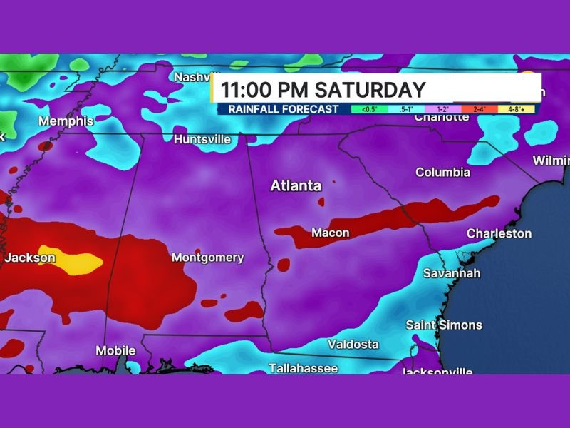
ATLANTA, GA — A much-needed soaking rain event was forecast to push across drought-stricken Georgia tonight and through Saturday, bringing rainfall totals between 1 and 2 inches across a state desperately in need of precipitation, with rainfall forecast imagery showing widespread and heavy rain coverage blanketing Georgia through 11 PM Saturday.
The rainfall event carried particular significance for South Georgia, where ongoing fire conditions had made heavy rain not just welcome but critically necessary, with hopes that the heaviest rain bands would position themselves far enough south to deliver meaningful relief to the fire-affected areas of the state.
Drought-Stricken Georgia Desperately Needs the Rain
Rainfall totals of 1 to 2 inches across drought-stricken Georgia represented a meaningful and welcome infusion of moisture for a state that had been dealing with dry and difficult conditions. The widespread nature of the rainfall event, visible across the full extent of the Georgia forecast map, pointed to broad coverage that could deliver relief across multiple regions simultaneously.
The exact positioning of the heaviest rain bands remained to be determined at the time of the forecast, leaving some uncertainty around which specific communities would receive the most significant rainfall accumulations from the overnight and Saturday event.
Heavy Rain Bands Visible Across Atlanta, Macon, and Coastal Georgia
Rainfall forecast imagery valid through 11 PM Saturday showed deep red and purple precipitation signatures concentrated across a wide swath of Georgia stretching from Atlanta and Macon southward through Savannah, Saint Simons, Valdosta, and toward the Florida border near Tallahassee and Jacksonville.
The 2 to 4 inch rainfall range was clearly depicted across the Macon corridor and extending eastward toward Charleston and the South Carolina coast, while broader accumulations in the 1 to 2 inch range covered the majority of the state including Atlanta and surrounding metro communities.
South Georgia Fire Relief Hinges on Rain Band Positioning
The most critical element of the rainfall forecast for Georgia centered on whether the heaviest rain bands would track far enough south to deliver meaningful precipitation across South Georgia fire-affected areas. The positioning of those bands remained uncertain at the time of the forecast, making the exact distribution of the highest rainfall totals across southern portions of the state a key variable to monitor as the event developed through Saturday.
Any significant rainfall reaching South Georgia carried the potential to provide meaningful relief to fire conditions that had persisted across that portion of the state during the drought period leading into the weekend rain event.
Broader Regional Coverage Extends Beyond Georgia
The rainfall event extended well beyond Georgia’s borders, with forecast imagery showing widespread precipitation coverage across Alabama, Mississippi, Tennessee, South Carolina, and into North Carolina and Virginia. Communities including Montgomery, Mobile, Huntsville, Nashville, Memphis, Columbia, and Charlotte all fell within the broader rainfall footprint of the multi-state precipitation event pushing through the Southeast through Saturday night.
For continuing coverage of weather events and critical storm analysis across the United States, visit SaludaStandard-Sentinel.com.