Tornado Possible Severe Storm Warning Issued Across South Texas as Dangerous Storm Tracks Toward Corpus Christi Alice and Kingsville From the Laredo Corridor
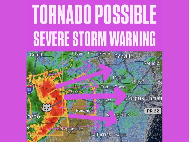
CORPUS CHRISTI, TX — A tornado possible severe storm warning has been issued across South Texas as a dangerous and intensely rotating storm system tracks eastward from the Laredo corridor toward Corpus Christi, Alice, and Kingsville. Radar imagery shows intense red and orange reflectivity returns concentrated along the western edge of the warning zone, with multiple active warning polygons outlined in orange covering a broad swath of South Texas communities in the direct path of the advancing storm.
Intense Storm Tracking Eastward From Laredo Toward Alice and Corpus Christi
The storm system generating this tornado possible severe storm warning is currently located near and west of the Freer and Benavides corridors along Highway 59, tracking rapidly eastward across South Texas. Multiple directional arrows on the radar display indicate the storm’s eastward and east-northeast movement toward Alice, Orange Grove, Mathis, and ultimately the Corpus Christi metropolitan area as the most dangerous portions of the storm continue pushing toward the heavily populated Gulf Coast communities.
Radar returns show deep red and orange signatures within the warning polygon, confirming the presence of an intense and well organized storm core capable of producing tornado activity as it advances through the South Texas brush country toward the coast.
Tornado Possible Warning Covers Freer Benavides Hebbronville and Surrounding Communities
The active warning polygon covers a significant zone across South Texas encompassing Freer, Benavides, Hebbronville, Falfurrias, and surrounding communities in the immediate path of the storm’s current track. Communities including Tilden, Three Rivers, and Orange Grove also fall within the broader threat zone as the storm continues its eastward progression through the South Texas corridor during the warning period.
Residents across all communities within the outlined warning polygon are directed to take shelter immediately in the lowest interior room of a sturdy structure and remain sheltered until the storm passes and the warning is officially lifted.
Corpus Christi Kingsville and Coastal Communities Must Prepare for Imminent Arrival
The storm’s eastward track places the Corpus Christi metropolitan area, Kingsville, Sinton, and surrounding coastal South Texas communities directly in the path of this tornado capable severe storm as it continues its rapid progression toward the Gulf Coast. The combination of the tornado possible designation and the storm’s movement toward densely populated coastal communities makes this an urgent and serious situation requiring immediate action from all residents across the warning zone.
All South Texas residents between the current storm location and the Corpus Christi coastline are urged to take shelter now and monitor official National Weather Service updates continuously until the warning expires.
For continuing coverage of tornado warnings and severe weather emergencies across the United States, visit SaludaStandard-Sentinel.com.