Waves of Rain and Storms With Damaging Wind Threat Arrive Across Miami Valley and Central Indiana After 10 PM Monday With Tornado Risk Remaining Unlikely on April 27
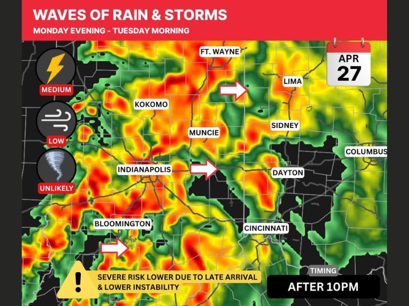
MIAMI VALLEY, OH — Waves of rain and storms were forecast to push across the Miami Valley, central Indiana, and surrounding regions beginning after 10 PM on Monday, April 27, 2026, as HRRR model simulated radar pointed to a lower overall severe risk for the area driven by reduced atmospheric instability and a later storm arrival window.
While loud storms with frequent lightning and heavy rainfall were expected through Monday evening into Tuesday morning, the tornado threat for the Miami Valley was not a primary concern, with the most significant tornado risk concentrated further west across Illinois and western Indiana.
Severe Risk Reduced by Late Arrival and Lower Instability
Two key factors worked to suppress the severe weather potential across the Miami Valley and central Indiana heading into Monday night. Lower atmospheric instability compared to regions further west and a later storm arrival time pushing impact well past 10 PM both contributed to a reduced severe weather environment for the area.
Despite the lower overall severe risk, a small chance remained for one or two storms to briefly turn severe and produce damaging winds during the Monday evening into Tuesday morning window, keeping the threat level at medium for lightning activity while wind risk stayed low and tornado potential was rated unlikely.
Storm Timing and Affected Communities
Simulated radar imagery showed waves of precipitation pushing eastward across a broad area encompassing Indianapolis, Muncie, Kokomo, Bloomington, Dayton, Cincinnati, Lima, Sidney, Ft. Wayne, and Columbus. Storm arrows on the forecast imagery indicated a consistent eastward movement of the precipitation bands through the overnight period.
The daytime hours on Monday were expected to remain dry for most if not all daylight hours across the region, giving residents a clear window to complete outdoor activities before rain and storms arrived after 10 PM.
Primary Tornado Threat Remains to the West
While the Miami Valley maintained a low but nonzero severe weather risk, the most dangerous tornado setup for Monday night was positioned across Illinois and western Indiana. The atmospheric setup across those regions carried a significantly more favorable environment for tornado development compared to the conditions expected further east across Ohio.
Residents in the Miami Valley were advised to stay weather aware through the day as new model data came in, remain alert after 10 PM as storm waves moved through, and have a shelter plan ready in the event that any isolated storm briefly reached severe criteria through the overnight hours into Tuesday morning.
For continuing coverage of severe weather events and critical storm analysis across the United States, visit SaludaStandard-Sentinel.com.